1940s Maps of La Prairie, Illinois
Explore 3 historic maps of La Prairie from the 1940s. These maps offer a rare glimpse into what life looked like during the 1940s — showing old roads, neighborhoods, homes, and landmarks that have changed or disappeared over time.
Whether you're researching your family's past, planning a metal detecting trip, or studying how La Prairie's landscape evolved across the 1940s, these high-resolution maps are a powerful tool for exploring the history of this region.
- Focus on a specific era: All maps on this page are from the 1940s, giving you a focused view of this time period.
- See what’s changed: Compare century-old streets, trails, and buildings to today's modern landscape using overlays and satellite layers.
- Research with precision: Use these maps for genealogy, historical research, land use analysis, or educational projects.
- View, download, or print: Maps are fully viewable online in high resolution, and can be downloaded or printed for your own records.
Start exploring La Prairie's history through authentic maps from the 1940s. This is your window into the past.
La Prairie, IL maps
(3)- 1946 Map of Augusta, 1957 Print
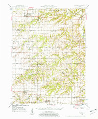 1946 Augusta1957 Print · USGSWestern Illinois farm country at the end of the 1940s is detailed here as the rail-and-river economy transitions. Genealogists can trace family names at Sherwood Cem and Woodland Cem, or locate rural landmarks like Mt Horeb Ch and Timewell PO.2 unique versions available
 - 1948 Map of Camp Point
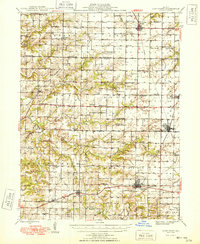 1948 Camp Point1948 Print · USGSWestern Illinois farm country thrives in the late 1940s, marked by a dense grid of township roads and early rail connections. Genealogists can locate dozens of country schools and burial grounds, from Lone Star Sch to the Friedhof Cem and Bowen Cem.2 unique versions available
 - 1949 Map of Augusta
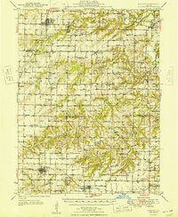 1949 Augusta1949 Print · USGSWestern Illinois at the end of the 1940s reveals a landscape of tight-knit rural communities and school districts. Genealogists can trace family footprints across dozens of local landmarks like Sulphur Springs Sch, Woodland Cem, and Mound Station Timewell PO.
End of results
Showing maps 1-3 of 3
Top cities near La Prairie
- Mount Sterling historical maps
- Camp Point historical maps
- Clayton historical maps
- Chili historical maps
- Augusta historical maps
- Golden historical maps
See more
Frequently asked questions
- What are the different types of historical maps available for La Prairie?
- What is the oldest map of La Prairie?
- Where can I purchase historical maps of La Prairie for my home or office?
- Where can I download high-res historical maps of La Prairie?
- Are there historical topographic maps available for La Prairie?
- Is there historical aerial imagery available for La Prairie?
- Where are historical maps of La Prairie sourced from?