1980s Maps of Lakeshore Hills, Illinois
Explore 2 historic maps of Lakeshore Hills from the 1980s. These maps offer a rare glimpse into what life looked like during the 1980s — showing old roads, neighborhoods, homes, and landmarks that have changed or disappeared over time.
Whether you're researching your family's past, planning a metal detecting trip, or studying how Lakeshore Hills's landscape evolved across the 1980s, these high-resolution maps are a powerful tool for exploring the history of this region.
- Focus on a specific era: All maps on this page are from the 1980s, giving you a focused view of this time period.
- See what’s changed: Compare century-old streets, trails, and buildings to today's modern landscape using overlays and satellite layers.
- Research with precision: Use these maps for genealogy, historical research, land use analysis, or educational projects.
- View, download, or print: Maps are fully viewable online in high resolution, and can be downloaded or printed for your own records.
Start exploring Lakeshore Hills's history through authentic maps from the 1980s. This is your window into the past.
Lakeshore Hills, IL maps
(2)- 1981 Map of Columbus
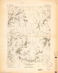 1981 Columbus1981 Print · USGSAdams County in the early eighties was defined by its rolling creek drainages and quiet township crossroads. Genealogists and local historians can trace family sites at Mt Pleasant Cem and Independence Cem, or locate landmarks like the Townhall near Burton.2 unique versions available
 - 1986 Map of Quincy
 1986 Quincy1986 Print · USGSThe tri-state border region along the Mississippi River comes into focus during the mid-1980s. Researchers can trace the legacy of river towns and rail hubs like Quincy and Monroe City or locate landmarks such as Mount Olive Cem.2 unique versions available
End of results
Showing maps 1-2 of 2
Top cities near Lakeshore Hills
- Quincy historical maps
- Hannibal historical maps
- Camp Point historical maps
- Payson historical maps
- Mendon historical maps
- Burton historical maps
See more
Frequently asked questions
- What are the different types of historical maps available for Lakeshore Hills?
- What is the oldest map of Lakeshore Hills?
- Where can I purchase historical maps of Lakeshore Hills for my home or office?
- Where can I download high-res historical maps of Lakeshore Hills?
- Are there historical topographic maps available for Lakeshore Hills?
- Is there historical aerial imagery available for Lakeshore Hills?
- Where are historical maps of Lakeshore Hills sourced from?