1900s (20th Century) Maps of Quincy, Illinois
Explore 10 historic maps of Quincy from the 1900s (20th Century). These maps offer a rare glimpse into what life looked like during the 1900s — showing old roads, neighborhoods, homes, and landmarks that have changed or disappeared over time.
Whether you're researching your family's past, planning a metal detecting trip, or studying how Quincy's landscape evolved across the 1900s, these high-resolution maps are a powerful tool for exploring the history of this region.
- Focus on a specific era: All maps on this page are from the 1900s, giving you a focused view of this time period.
- See what’s changed: Compare century-old streets, trails, and buildings to today's modern landscape using overlays and satellite layers.
- Research with precision: Use these maps for genealogy, historical research, land use analysis, or educational projects.
- View, download, or print: Maps are fully viewable online in high resolution, and can be downloaded or printed for your own records.
Start exploring Quincy's history through authentic maps from the 1900s. This is your window into the past.
Quincy, IL maps
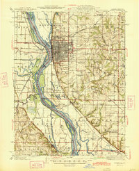
(10)- 1925 Map of Quincy
 1925 Quincy1925 Print · USGSQuincy and its Mississippi River hinterlands are captured in the mid-1920s, showing a landscape defined by river navigation and rail transport. Genealogists can locate dozens of country schools and churches, from St Ludgerus School to Zion Church and the Soldiers Home.2 unique versions available
 - 1944 Map of Quincy, 1954 Print
 1944 Quincy1954 Print · USGSQuincy and the Mississippi River valley are captured in the 1940s, showing a landscape defined by rail lines and rural parish schools. Researchers can trace the riverfront at Marion City, the grounds of the Soldiers Home, and historic sites like Zion Church.5 unique versions available
 - 1945 Map of Quincy
 1945 Quincy1945 Print · USGSQuincy and its Mississippi River crossings are captured here in the mid-1940s during a period of transition for its riverfront and rail lines. Genealogists can trace family roots at local landmarks like the Soldiers Home, Melrose Chapel, and numerous rural schoolhouses such as Hickory Grove School.2 unique versions available
 - 1948 Map of Quincy
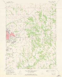
 1948 Quincy1948 Print · USGSThe Mississippi and Illinois River valleys are captured at a post-war crossroads as rail and river travel met the expanding highway system. Genealogists can trace family settlements from Quincy to Hannibal and smaller towns like Vandalia and Jerseyville.2 unique versions available
 - 1956 Map of Quincy, 1967 Print
 1956 Quincy1967 Print · USGSThe river and rail corridors of the Illinois-Missouri border are documented here during the mid-1950s. Researchers can trace historic river landings and regional transit hubs from Quincy and Hannibal to smaller settlements like Meredosia and Roodhouse.3 unique versions available
 - 1971 Map of Quincy East, 1973 Print
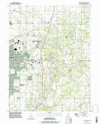
 1971 Quincy East1973 Print · USGSEastern Quincy and the surrounding Adams County townships are captured here in the early seventies as the city grid pushed toward the rural prairie. Genealogists can locate several family burial grounds including Powell Cem and Eeds Cem, alongside landmarks like Melrose Chapel and Hickory Grove.2 unique versions available
 - 1971 Map of Quincy West, 1973 Print
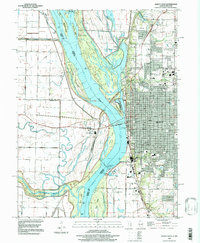
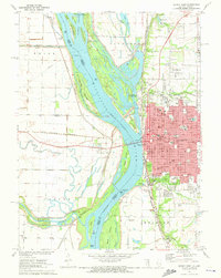 1971 Quincy West1973 Print · USGSThe riverfront city of Quincy is shown in the early seventies, at the height of its mid-century industrial and civic development. Researchers can trace local institutions and family names at Woodland Cem, Quincy College, and the Illinois Soldiers and Sailors Home.
 - 1986 Map of Quincy
 1986 Quincy1986 Print · USGSThe tri-state border region along the Mississippi River comes into focus during the mid-1980s. Researchers can trace the legacy of river towns and rail hubs like Quincy and Monroe City or locate landmarks such as Mount Olive Cem.2 unique versions available
 - 1995 Map of Quincy East, 1998 Print
 1995 Quincy East1998 Print · USGSThe eastern edges of Quincy and the rural outskirts of Adams County are shown here during a period of late-century expansion. Genealogists can trace family names across a high density of burial grounds like National Cem, Powell Cem, and the historic Melrose Chapel.
 - 1996 Map of Quincy West, 1997 Print
 1996 Quincy West1997 Print · USGSThe riverfront at Quincy and the Illinois-Missouri border are captured here in the mid-1990s as the city expands along the eastern bluffs. Researchers can trace the river's complex island system, industrial mines, and local landmarks like St Boniface Cem and the Quincy Mem Bridge.
End of results
Showing maps 1-10 of 10
Top cities near Quincy
- Hannibal historical maps
- Palmyra historical maps
- Canton historical maps
- Payson historical maps
- La Grange historical maps
- Mendon historical maps
See more
Top neighborhoods of Quincy
- Northridge historical maps
- South Park Terrace historical maps
- Glendale historical maps
- Lincoln Hills historical maps
- Woodlawn Court historical maps
- Holiday Hills historical maps
See more
Frequently asked questions
- What are the different types of historical maps available for Quincy?
- What is the oldest map of Quincy?
- Where can I purchase historical maps of Quincy for my home or office?
- Where can I download high-res historical maps of Quincy?
- Are there historical topographic maps available for Quincy?
- Is there historical aerial imagery available for Quincy?
- Where are historical maps of Quincy sourced from?