1990s Maps of Aurora, Illinois
Explore 8 historic maps of Aurora from the 1990s. These maps offer a rare glimpse into what life looked like during the 1990s — showing old roads, neighborhoods, homes, and landmarks that have changed or disappeared over time.
Whether you're researching your family's past, planning a metal detecting trip, or studying how Aurora's landscape evolved across the 1990s, these high-resolution maps are a powerful tool for exploring the history of this region.
- Focus on a specific era: All maps on this page are from the 1990s, giving you a focused view of this time period.
- See what’s changed: Compare century-old streets, trails, and buildings to today's modern landscape using overlays and satellite layers.
- Research with precision: Use these maps for genealogy, historical research, land use analysis, or educational projects.
- View, download, or print: Maps are fully viewable online in high resolution, and can be downloaded or printed for your own records.
Start exploring Aurora's history through authentic maps from the 1990s. This is your window into the past.
Aurora, IL maps
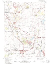
(8)- 1993 Map of Aurora South, 1994 Print
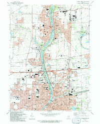
 1993 Aurora South1994 Print · USGSThe Fox River corridor shows significant suburban growth in the early nineties as residential developments expand around Oswego. Genealogists and local historians can trace family sites at Oswego Prairie Cemetery and the small settlement of Wolfs.
 - 1993 Map of Yorkville, 1994 Print
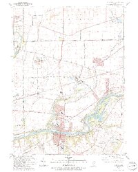 1993 Yorkville1994 Print · USGSThe Fox River valley in the early nineties shows a landscape of river-front parks and historic transit routes. Genealogists can trace family names at St Patricks Cem and Oak Grove Cem or locate the Glen D Palmer State Game Farm.
 - 1993 Map of Aurora North, 1994 Print
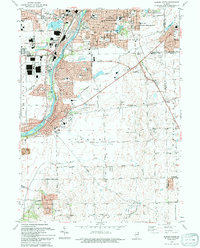
 1993 Aurora North1994 Print · USGSThe Fox River valley was thriving in the 1990s as it balanced industrial heritage with cutting-edge science and education. Genealogists and researchers can locate numerous landmarks including Mt Olivet Cem, the Marmion Military Academy, and the Fermi National Accelerater Laboratory.
 - 1993 Map of Normantown, 1994 Print
 1993 Normantown1994 Print · USGSWill County’s transition from prairie farmland to bustling suburban corridor is captured here in the early nineties. Genealogists and local researchers can trace family landmarks like Vermont Cem, the Wheatland-Salem Ch, and the rail lines of the Elgin Joliet and Eastern RR.
 - 1993 Map of Naperville, 1994 Print
 1993 Naperville1994 Print · USGSThe western suburbs of Chicago are seen here in the early nineties during a period of intense suburban development. Genealogists and historians can trace local family landmarks and institutional growth at North Central College, Assumption Cem, and Fermi National Accelerator Laboratory.
 - 1993 Map of Sugar Grove, 1994 Print
 1993 Sugar Grove1994 Print · USGSThe Kane County countryside near the end of the twentieth century shows a landscape transitioning from rural gravel mining to suburban expansion. Genealogists and historians can trace family landmarks like Sugar Grove Cem, Johnsons Mound, and the Waubonsee Community College campus.
 - 1998 Map of Naperville, 2002 Print
 1998 Naperville2002 Print · USGSNaperville and Wheaton undergo significant suburban expansion in the late 1990s as modern transit and scientific hubs reshape the DuPage County landscape. Researchers can trace local development through landmarks like North Central College, Cantigny Park, and the Fermi National Accelerator Laboratory.
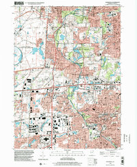
 - 1998 Map of Aurora North, 2002 Print
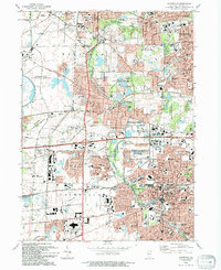
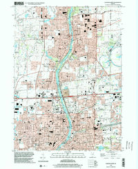 1998 Aurora North2002 Print · USGSThe Fox River valley in the late 1990s shows a unique mix of high-tech research and historic riverfront communities. Researchers can trace the development of Fermilab, locate family plots at Pioneer Cem, or find the campus of Marmion Military Academy.
End of results
Showing maps 1-8 of 8
Top cities near Aurora
- Joliet historical maps
- Naperville historical maps
- Elgin historical maps
- Bolingbrook historical maps
- Wayne historical maps
- Wheaton historical maps
See more
Frequently asked questions
- What are the different types of historical maps available for Aurora?
- What is the oldest map of Aurora?
- Where can I purchase historical maps of Aurora for my home or office?
- Where can I download high-res historical maps of Aurora?
- Are there historical topographic maps available for Aurora?
- Is there historical aerial imagery available for Aurora?
- Where are historical maps of Aurora sourced from?