1950s Maps of Aurora, Illinois
Explore 9 historic maps of Aurora from the 1950s. These maps offer a rare glimpse into what life looked like during the 1950s — showing old roads, neighborhoods, homes, and landmarks that have changed or disappeared over time.
Whether you're researching your family's past, planning a metal detecting trip, or studying how Aurora's landscape evolved across the 1950s, these high-resolution maps are a powerful tool for exploring the history of this region.
- Focus on a specific era: All maps on this page are from the 1950s, giving you a focused view of this time period.
- See what’s changed: Compare century-old streets, trails, and buildings to today's modern landscape using overlays and satellite layers.
- Research with precision: Use these maps for genealogy, historical research, land use analysis, or educational projects.
- View, download, or print: Maps are fully viewable online in high resolution, and can be downloaded or printed for your own records.
Start exploring Aurora's history through authentic maps from the 1950s. This is your window into the past.
Aurora, IL maps
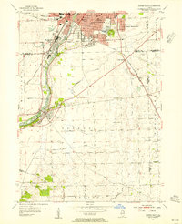
(9)- 1950 Map of Aurora North
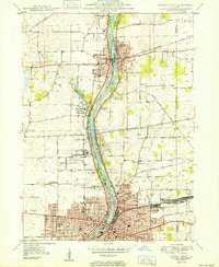 1950 Aurora North1950 Print · USGSKane County's river-driven industrial corridor is in full mid-century expansion between Batavia and Aurora. Genealogists and researchers can trace local institutions and schools such as Mooseheart, Aurora College, and Neilson Grove Sch.
 - 1953 Map of Naperville, 1955 Print
 1953 Naperville1955 Print · USGSDuPage County was transitioning from a rural rail corridor to a suburban heartland in the early 1950s. Genealogists and historians can trace old schoolhouse sites like Round Grove Sch and landmarks including North Central College and the Winfield Sanitarium.
 - 1953 Map of Yorkville, 1955 Print
 1953 Yorkville1955 Print · USGSThe Fox River valley in the early 1950s shows the development of Kendall County just as suburban patterns began to reach the prairie. Researchers can trace historic family burial sites at Jericho Cem or locate the site of the Keck Sch (Abandoned) and Bristol (PO and Sta).3 unique versions available
 - 1953 Map of Normantown, 1955 Print
 1953 Normantown1955 Print · USGSThe rural prairies of Du Page and Will counties are shown in the early fifties as the region transitioned toward modernization. Genealogists can trace early family sites like Vermont Cem, Wheatland Sch, and the rail stop at Normantown.
 - 1954 Map of Aurora South, 1955 Print
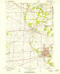
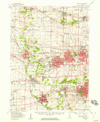
 1954 Aurora South1955 Print · USGSThe Fox River valley and the southern reaches of Aurora are captured in the mid-fifties, showing a landscape of growing suburbs and rural prairie. Genealogists can trace family names at Mt Olivet Cem or locate the rural Oswego Prairie Ch and Scotch Sch.4 unique versions available
 - 1954 Map of Yorkville, 1959 Print
 1954 Yorkville1959 Print · USGSKendall County in the mid-1950s shows a balance between growing riverside towns and an expansive agricultural interior. Genealogists can trace family roots through rural landmarks like Naausay Ch, Jericho Cem, and the long-standing diagonal of the Old Indian Boundary.2 unique versions available
 - 1954 Map of Wheaton, 1960 Print
 1954 Wheaton1960 Print · USGSDuPage County transitions from its agricultural roots to a bustling suburban corridor during the mid-fifties. Genealogists and historians can trace institutional landmarks like the Zace Sanitarium, Old Ontarioville Cem, and Sacred Heart Academy before later development.2 unique versions available
 - 1954 Map of Joliet, 1960 Print
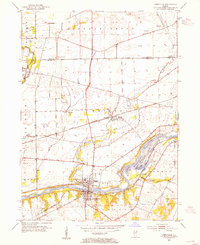
 1954 Joliet1960 Print · USGSMid-century Joliet and Plainfield are captured here during a period of heavy industrial and transit growth. Researchers can trace the alignment of the Lincoln Highway and find localized details like the State Prison Farm and Caton Farm.
 - 1958 Map of Aurora, 1969 Print
 1958 Aurora1969 Print · USGSNorthern Illinois in the late fifties shows a landscape of powerful river industry and expanding transport corridors. Genealogists and historians can trace the development of Aurora and Joliet or locate sites like the Elwood Ordnance Plant and Starved Rock.3 unique versions available
End of results
Showing maps 1-9 of 9
Top cities near Aurora
- Joliet historical maps
- Naperville historical maps
- Elgin historical maps
- Bolingbrook historical maps
- Wayne historical maps
- Wheaton historical maps
See more
Frequently asked questions
- What are the different types of historical maps available for Aurora?
- What is the oldest map of Aurora?
- Where can I purchase historical maps of Aurora for my home or office?
- Where can I download high-res historical maps of Aurora?
- Are there historical topographic maps available for Aurora?
- Is there historical aerial imagery available for Aurora?
- Where are historical maps of Aurora sourced from?