1970s Maps of Brown County, Illinois
Explore 3 historic maps of Brown County from the 1970s. These maps offer a rare glimpse into what life looked like during the 1970s — showing old roads, neighborhoods, homes, and landmarks that have changed or disappeared over time.
Whether you're researching your family's past, planning a metal detecting trip, or studying how Brown County's landscape evolved across the 1970s, these high-resolution maps are a powerful tool for exploring the history of this region.
- Focus on a specific era: All maps on this page are from the 1970s, giving you a focused view of this time period.
- See what’s changed: Compare century-old streets, trails, and buildings to today's modern landscape using overlays and satellite layers.
- Research with precision: Use these maps for genealogy, historical research, land use analysis, or educational projects.
- View, download, or print: Maps are fully viewable online in high resolution, and can be downloaded or printed for your own records.
Start exploring Brown County's history through authentic maps from the 1970s. This is your window into the past.
Brown County, IL maps
(3)- 1975 Map of Meredosia SE, 1976 Print
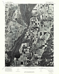 1975 Meredosia SE1976 Print · USGSThe Illinois River valley in the mid-1970s shows a landscape of riverfront commerce and productive floodplains. Genealogists and local historians can trace the footprints of Meredosia, Naples, and the edge of Bluffs as they appeared decades ago.
 - 1975 Map of Rushville SE, 1976 Print
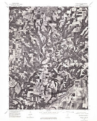 1975 Rushville SE1976 Print · USGSSchuyler County farmland and the southern outskirts of Rushville are captured in high detail during the mid-seventies. Trace the winding course of the La Moine River and examine the precise layout of local timber and farm fields.
 - 1975 Map of Augusta SW, 1976 Print
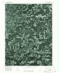 1975 Augusta SW1976 Print · USGSEastern Adams County is captured in mid-1970s aerial detail, revealing the precise layout of agricultural fields and rural roads. Genealogists and researchers can trace the specific footprints of farmsteads and the street grids of Clayton and Timewell.
End of results
Showing maps 1-3 of 3
Top cities of Brown County
- Mount Sterling historical maps
- Versailles historical maps
- Cooperstown historical maps
- Buckhorn historical maps
- Ripley historical maps
Frequently asked questions
- What are the different types of historical maps available for Brown County?
- What is the oldest map of Brown County?
- Where can I purchase historical maps of Brown County for my home or office?
- Where can I download high-res historical maps of Brown County?
- Are there historical topographic maps available for Brown County?
- Is there historical aerial imagery available for Brown County?
- Where are historical maps of Brown County sourced from?