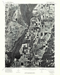
1975 Map of Meredosia SE
USGS Topo · Published 1976About this map
Meredosia sits prominently at a bend in the Illinois River in this mid-1970s orthophoto survey, showcasing the town's spatial relationship with the expansive Meredosia Lake to the north. This aerial perspective captures the river valley's transition from the residential and commercial layout of Meredosia down to the riverfront settlement of Naples and the edge of Bluffs. The patchwork of agricultural fields and levees across the floodplain reveals the intensity of land use and river management during this period. The orthophoto format provides a clear view of the transportation corridors and drainage patterns that define the economic life of this river-centered landscape in Morgan County.
Find a feature on this map
5 named features on this map. Tap any name to fly to it.
Don’t see what you’re looking for? This feature index may not catch every label — zoom into the map to look around manually.
Map Details
Editions of this 1975 Meredosia SE Map
This is the sole edition of this map. No revisions or reprints were ever made.
Other maps of this area

1924 · Winchester
USGS Topo · 1:48,000

1924 · Griggsville
USGS Topo · 1:62,500

1926 · Griggsville
USGS Topo · 1:62,500

1926 · Winchester
USGS Topo · 1:62,500

1928 · Meredosia
USGS Topo · 1:62,500
1929 · Arenzville
USGS Topo · 1:62,500

1931 · Meredosia
USGS Topo · 1:62,500
1932 · Arenzville
USGS Topo · 1:62,500

1948 · Quincy
USGS Topo · 1:250,000

1956 · Quincy
USGS Topo · 1:250,000