1990s Maps of Cabery, Illinois
Explore 2 historic maps of Cabery from the 1990s. These maps offer a rare glimpse into what life looked like during the 1990s — showing old roads, neighborhoods, homes, and landmarks that have changed or disappeared over time.
Whether you're researching your family's past, planning a metal detecting trip, or studying how Cabery's landscape evolved across the 1990s, these high-resolution maps are a powerful tool for exploring the history of this region.
- Focus on a specific era: All maps on this page are from the 1990s, giving you a focused view of this time period.
- See what’s changed: Compare century-old streets, trails, and buildings to today's modern landscape using overlays and satellite layers.
- Research with precision: Use these maps for genealogy, historical research, land use analysis, or educational projects.
- View, download, or print: Maps are fully viewable online in high resolution, and can be downloaded or printed for your own records.
Start exploring Cabery's history through authentic maps from the 1990s. This is your window into the past.
Cabery, IL maps
(2)- 1990 Map of Peoria
 1990 Peoria1990 Print · USGSCentral Illinois at the start of the nineties reveals a landscape of industrial river towns and sprawling university campuses. Researchers can trace the legacy of major institutions like Chanute Air Force Base and the University of Illinois alongside regional landmarks such as Sand Ridge State Forest.
 - 1998 Map of Cabery, 2003 Print
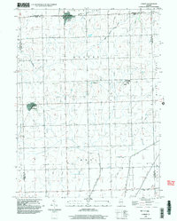 1998 Cabery2003 Print · USGSCabery and Kempton anchor this Illinois prairie landscape at the end of the twentieth century, showing a region deeply shaped by agricultural drainage and local townships. Genealogists can trace family burial grounds at Mount Hope Cem and Floridale Cem or explore the unique layout of Stelle.
End of results
Showing maps 1-2 of 2
Top cities near Cabery
- Dwight historical maps
- Gilman historical maps
- Herscher historical maps
- Gardner historical maps
- Braceville historical maps
- Essex historical maps
See more
Frequently asked questions
- What are the different types of historical maps available for Cabery?
- What is the oldest map of Cabery?
- Where can I purchase historical maps of Cabery for my home or office?
- Where can I download high-res historical maps of Cabery?
- Are there historical topographic maps available for Cabery?
- Is there historical aerial imagery available for Cabery?
- Where are historical maps of Cabery sourced from?