1900s (20th Century) Maps of Mozier, Illinois
Explore 7 historic maps of Mozier from the 1900s (20th Century). These maps offer a rare glimpse into what life looked like during the 1900s — showing old roads, neighborhoods, homes, and landmarks that have changed or disappeared over time.
Whether you're researching your family's past, planning a metal detecting trip, or studying how Mozier's landscape evolved across the 1900s, these high-resolution maps are a powerful tool for exploring the history of this region.
- Focus on a specific era: All maps on this page are from the 1900s, giving you a focused view of this time period.
- See what’s changed: Compare century-old streets, trails, and buildings to today's modern landscape using overlays and satellite layers.
- Research with precision: Use these maps for genealogy, historical research, land use analysis, or educational projects.
- View, download, or print: Maps are fully viewable online in high resolution, and can be downloaded or printed for your own records.
Start exploring Mozier's history through authentic maps from the 1900s. This is your window into the past.
Mozier, IL maps
(7)- 1930 Map of Pearl
 1930 Pearl1930 Print · USGSThe Illinois River valley in the late 1920s shows a landscape of river-bottom farms and rugged bluff-top settlements. Genealogists can locate family landmarks like Miller Cem, Farmers Ridge Ch, and schools such as Summit Grove Sch or Village Green Sch.3 unique versions available
 - 1948 Map of Quincy
 1948 Quincy1948 Print · USGSThe Mississippi and Illinois River valleys are captured at a post-war crossroads as rail and river travel met the expanding highway system. Genealogists can trace family settlements from Quincy to Hannibal and smaller towns like Vandalia and Jerseyville.2 unique versions available
 - 1950 Map of Pearl, 1956 Print
 1950 Pearl1956 Print · USGSThe Illinois River valley in the mid-1950s reveals a landscape of river-bottom farms and bluff-side settlements. Local researchers can trace family roots through numerous rural landmarks like Farmers Ridge Ch, Miller Cem, and Robley Sch.
 - 1956 Map of Quincy, 1967 Print
 1956 Quincy1967 Print · USGSThe river and rail corridors of the Illinois-Missouri border are documented here during the mid-1950s. Researchers can trace historic river landings and regional transit hubs from Quincy and Hannibal to smaller settlements like Meredosia and Roodhouse.3 unique versions available
 - 1978 Map of Pleasant Dale Valley
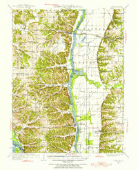
 1978 Pleasant Dale Valley1978 Print · USGSThe Illinois river bluffs and Mississippi bottomlands come alive in the late seventies, showing a landscape defined by deep hollows and river islands. Genealogists can locate family names at Hillcrest Cemetery and Spear Cemetery or trace the rural reach of Mozier Landing.
 - 1985 Map of Jerseyville
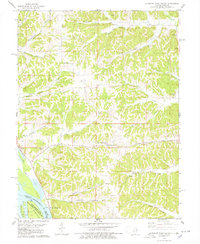
 1985 Jerseyville1985 Print · USGSThe confluence of the Illinois and Mississippi rivers defines this 1980s landscape of fertile bottomlands and rail-hub towns. Genealogists and historians can trace the foundations of communities like Jerseyville and White Hall alongside the Oak Grove Cem and St Mary Church.2 unique versions available
 - 1993 Map of Pleasant Dale Valley, 1996 Print
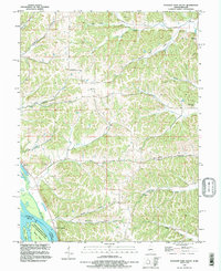 1993 Pleasant Dale Valley1996 Print · USGSThe confluence of the Mississippi and Illinois Rivers defines this pocket of Calhoun County in the 1990s. Genealogists and local historians can trace family plots at Hillcrest Cem or Silver Creek Cem and explore the riverbank geography of Mozier and Cliffdale.
End of results
Showing maps 1-7 of 7
Top cities near Mozier
- Elsberry historical maps
- Pleasant Hill historical maps
- Hardin historical maps
- Atlas historical maps
- Clarksville historical maps
- Martinsburg historical maps
See more
Frequently asked questions
- What are the different types of historical maps available for Mozier?
- What is the oldest map of Mozier?
- Where can I purchase historical maps of Mozier for my home or office?
- Where can I download high-res historical maps of Mozier?
- Are there historical topographic maps available for Mozier?
- Is there historical aerial imagery available for Mozier?
- Where are historical maps of Mozier sourced from?