Old Maps of Carroll County, Illinois
Explore 132 old maps of Carroll County, spanning from 1891 to today. These high-resolution historic maps reveal how streets, neighborhoods, landmarks, and natural features evolved over time — perfect for genealogy, metal detecting, research, and local history exploration.
What you can do with these maps:
- See how Carroll County changed over time: Compare historical maps to modern-day views to trace roads, homesites, rail lines & more.
- View detailed metadata: Each map includes creators, publishers, year, scale, and archive source.
- Overlay maps with satellite & LiDAR: Visualize the past alongside modern tools to explore terrain & human change.
- Trusted historical sources: Maps sourced from the USGS, Library of Congress, and other archives.
- Access maps your way: View online, download high-res files, or order prints for personal or research use.
Start exploring old maps of Carroll County to uncover forgotten places, hidden landmarks, and the deep history beneath your feet.
Carroll County, IL maps
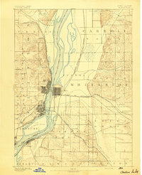
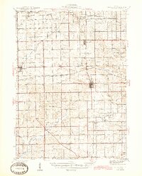
(132)- 1891 Map of Clinton
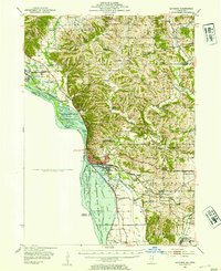
 1891 Clinton1891 Print · USGSThe Mississippi River corridor thrived as a dual-state rail hub in the 1890s, anchored by the riverfront centers of Clinton and Fulton. Researchers can trace the early tracks of the Chicago and Northwestern RR and locate vanished stops like Almont and Argo.
 - 1892 Map of Savanna
 1892 Savanna1892 Print · USGSThe upper Mississippi corridor in the late nineteenth century was a bustling hub of river commerce and competing rail lines. Map enthusiasts can trace the old tracks of the Chicago Burlington and Northern Railroad and locate vanished landmarks like Hickory Grove or Idens Lake.8 unique versions available
 - 1894 Map of Clinton
 1894 Clinton1894 Print · USGSThe riverfront communities of eastern Iowa and western Illinois are captured here in the late nineteenth century as rail expansion reached its peak. Researchers can trace early street grids in Clinton and Lyons or locate old rail junctions near Garden Plain and Almont.3 unique versions available
 - 1899 Map of Clinton
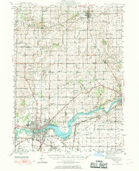
 1899 Clinton1899 Print · USGSThe Mississippi River valley comes alive in the late 1890s, capturing the river-and-rail economy of Iowa and Illinois before modern channelization. Genealogists and historians can trace early townships and river landings, finding precise locations for Low Moor, Folletts, and Pink Prairie.5 unique versions available
 - 1930 Map of Woodsung
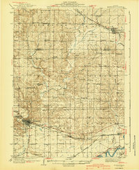
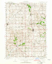
 1930 Woodsung1930 Print · USGSNorthern Illinois at the dawn of the 1930s shows a landscape of tight-knit farming townships linked by the Lincoln Highway. Genealogists and local historians can trace schoolhouse locations like Stone Sch and Gap Grove Sch, or locate family sites near the Prairieville Cem.
 - 1934 Map of Morrison
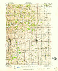
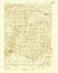 1934 Morrison1934 Print · USGSWhiteside County is seen here in the 1930s as a thriving agricultural landscape defined by the Chicago and Northwestern rail line. Researchers can trace rural school districts and family cemeteries such as Union Grove Cemetery, Coleta, and Milledgeville.2 unique versions available
 - 1935 Map of Miles, 1957 Print
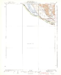
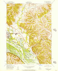
 1935 Miles1957 Print · USGSIn the mid-1930s, the Mississippi River shoreline was defined by military expansion and the rail economy. Genealogists and historians can trace the foundations of the Savanna Ordnance Depot and local landmarks like Whitton and Lost Mound Sch.
 - 1940 Map of Morrison
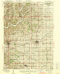
 1940 Morrison1940 Print · USGSWhiteside and Carroll counties thrive as a robust agricultural landscape during the late 1930s, defined by the twin engines of the Rock River and major rail lines. Genealogists can locate dozens of country schools like Ideal Sch and old cemeteries including Clyde Cem and Bethel Cem.2 unique versions available
 - 1941 Map of Miles
 1941 Miles1941 Print · USGSThe Mississippi River borderlands come alive in this pre-war survey, documenting the small settlements and rail lines that defined the Jo Daviess and Carroll County line. Researchers can trace the river's complex island system or find local landmarks like Whitton, Lost Mound, and the Lost Mound Sch.2 unique versions available
 - 1942 Map of Mt Carroll, 1959 Print
 1942 Mt Carroll1959 Print · USGSNorthwest Illinois farmland is mapped here just after the start of the war, showing a landscape tightly connected by rail and rural schools. Genealogists can locate family landmarks like Sabin Ch, the Spring Valley Cem, or rail stops at Ashdale Junc and Kittredge.2 unique versions available
 - 1942 Map of Forreston, 1965 Print
 1942 Forreston1965 Print · USGSForreston and the surrounding Ogle County prairie are shown during a height of rail activity in the 1940s. Genealogists can trace family roots through numerous country schools like White Oak Sch and rural landmarks such as Prairie Dell Ch and Shelly Cem.2 unique versions available
 - 1944 Map of Mt Carroll
 1944 Mt Carroll1944 Print · USGSThe Carroll County landscape during the mid-1940s was defined by a dense network of country schools and the vital crossroads of the Milwaukee Road. Genealogists and historians can trace old homesteads near St Wendelin Cem, Ashdale Junc, and Loran.2 unique versions available
 - 1945 Map of Forreston
 1945 Forreston1945 Print · USGSIn the mid-1940s, the rural landscapes of Ogle and Stephenson counties were defined by a sprawling network of one-room schoolhouses and busy rail lines. Genealogists and historians can trace family roots at West Grove Ch, Maryland, and schools like Wall Sch or Good Sch.2 unique versions available
 - 1946 Map of Sterling, 1969 Print
 1946 Sterling1969 Print · USGSThe Rock River corridor in the mid-1940s is captured here, showing the industrial heart of the region alongside its deep agricultural roots. Researchers can find dozens of country schools and cemeteries, including Buffalo Grove Sch, Zion Cem, and Oak Knoll Mem Park Cem.
 - 1948 Map of Sterling
 1948 Sterling1948 Print · USGSMid-century Sterling and Rock Falls are captured here during a time of robust rail and river activity. Genealogists can trace family roots through dozens of rural landmarks, including the Prairieville settlement, West Science Ridge Ch, and Hitt Cem.2 unique versions available
 - 1952 Map of Clinton, 1953 Print
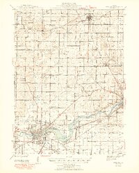
 1952 Clinton1953 Print · USGSThe Illinois-Iowa border along the Mississippi River is captured here in the early fifties, showing a landscape defined by industrial rail lines and wildlife refuges. Trace family roots through specific rural landmarks like York Ch, Cottonwood Sch, and Calvary Cem.2 unique versions available
 - 1952 Map of Savanna, 1954 Print
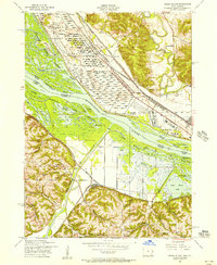
 1952 Savanna1954 Print · USGSThe Mississippi River bluffs and rail corridors define this Illinois riverfront during the early fifties. Genealogists and historians can trace numerous rural schoolhouses and family-named cemeteries like Massbach Cem, Palsgrove, and the sprawling Savanna Ordnance Depot.3 unique versions available
 - 1953 Map of Blackhawk, 1956 Print
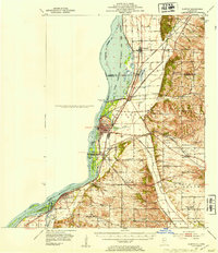
 1953 Blackhawk1956 Print · USGSThe river bluffs and backwaters of the Mississippi River come to life in this mid-century survey of the Illinois and Iowa borderlands. Researchers can trace the river's industrial and social pulse through sites like Arnolds Landing, St Mathews Ch, and the winding Chicago Milwaukee St Paul and Pacific rail lines.3 unique versions available
 - 1953 Map of Green Island, 1956 Print
 1953 Green Island1956 Print · USGSThe Mississippi River backwaters and the Savanna Ordnance Depot define this mid-century borderland between Iowa and Illinois. Genealogists and researchers can trace rural life through the Lost Mound Cem, Grand View Sch, and the rail stop at Whitton.3 unique versions available
 - 1954 Map of Rockford
 1954 Rockford1954 Print · USGSThe Rock River valley and the Illinois-Wisconsin borderlands are captured here in the mid-1950s during a period of robust industrial and agricultural activity. Genealogists and historians can trace rail-era corridors like the Illinois Central RR and locate landmarks from Big Foot Prairie to Lake Geneva.
 - 1955 Map of Rockford
 1955 Rockford1955 Print · USGSThe Rock River valley and southern Wisconsin dairy country are shown here in the mid-fifties as the region's manufacturing centers grew. Genealogists and historians can trace the paths of the Chicago and North Western RR and Illinois Central RR through hubs like Rockford and Beloit.
 - 1958 Map of Davenport, 1968 Print
 1958 Davenport1968 Print · USGSEastern Iowa and western Illinois thrive along the river during the late fifties, defined by the industrial Quad Cities and a robust rail network. Genealogists can trace family roots through settlements like Oasis and Stanwood or along the Cedar River.2 unique versions available
 - 1958 Map of Aurora, 1969 Print
 1958 Aurora1969 Print · USGSNorthern Illinois in the late fifties shows a landscape of powerful river industry and expanding transport corridors. Genealogists and historians can trace the development of Aurora and Joliet or locate sites like the Elwood Ordnance Plant and Starved Rock.3 unique versions available
 - 1958 Map of Rockford, 1974 Print
 1958 Rockford1974 Print · USGSNorthern Illinois and southern Wisconsin are shown here in the mid-twentieth century as rail-dependent industrial towns began to interface with growing lakefront communities. Genealogists can trace family roots through settlements like Saylesville and Tess Corners or locate historical landmarks like the Rockford Ordnance Depot.4 unique versions available
 - 1959 Map of Dubuque, 1982 Print
 1959 Dubuque1982 Print · USGSThe Tri-State region comes alive in the mid-twentieth century as a hub of river commerce and rail transit. Genealogists and historians can trace the paths of the Illinois Central Gulf through Dubuque or locate the Savanna Ordnance Depot and Lock and Dam No 11.
Showing maps 1-25 of 132
Top cities of Carroll County
- Savanna historical maps
- Mount Carroll historical maps
- Lanark historical maps
- Milledgeville historical maps
- Shannon historical maps
- Thomson historical maps
See more
Frequently asked questions
- What are the different types of historical maps available for Carroll County?
- What is the oldest map of Carroll County?
- Where can I purchase historical maps of Carroll County for my home or office?
- Where can I download high-res historical maps of Carroll County?
- Are there historical topographic maps available for Carroll County?
- Is there historical aerial imagery available for Carroll County?
- Where are historical maps of Carroll County sourced from?