1950s Maps of Carroll County, Illinois
Explore 10 historic maps of Carroll County from the 1950s. These maps offer a rare glimpse into what life looked like during the 1950s — showing old roads, neighborhoods, homes, and landmarks that have changed or disappeared over time.
Whether you're researching your family's past, planning a metal detecting trip, or studying how Carroll County's landscape evolved across the 1950s, these high-resolution maps are a powerful tool for exploring the history of this region.
- Focus on a specific era: All maps on this page are from the 1950s, giving you a focused view of this time period.
- See what’s changed: Compare century-old streets, trails, and buildings to today's modern landscape using overlays and satellite layers.
- Research with precision: Use these maps for genealogy, historical research, land use analysis, or educational projects.
- View, download, or print: Maps are fully viewable online in high resolution, and can be downloaded or printed for your own records.
Start exploring Carroll County's history through authentic maps from the 1950s. This is your window into the past.
Carroll County, IL maps
(10)- 1952 Map of Clinton, 1953 Print
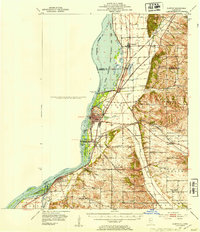 1952 Clinton1953 Print · USGSThe Illinois-Iowa border along the Mississippi River is captured here in the early fifties, showing a landscape defined by industrial rail lines and wildlife refuges. Trace family roots through specific rural landmarks like York Ch, Cottonwood Sch, and Calvary Cem.2 unique versions available
 - 1952 Map of Savanna, 1954 Print
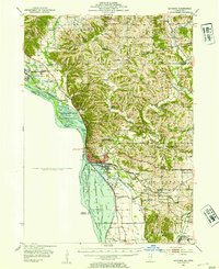 1952 Savanna1954 Print · USGSThe Mississippi River bluffs and rail corridors define this Illinois riverfront during the early fifties. Genealogists and historians can trace numerous rural schoolhouses and family-named cemeteries like Massbach Cem, Palsgrove, and the sprawling Savanna Ordnance Depot.3 unique versions available
 - 1953 Map of Blackhawk, 1956 Print
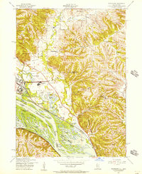 1953 Blackhawk1956 Print · USGSThe river bluffs and backwaters of the Mississippi River come to life in this mid-century survey of the Illinois and Iowa borderlands. Researchers can trace the river's industrial and social pulse through sites like Arnolds Landing, St Mathews Ch, and the winding Chicago Milwaukee St Paul and Pacific rail lines.3 unique versions available
 - 1953 Map of Green Island, 1956 Print
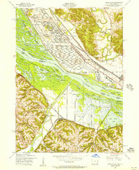 1953 Green Island1956 Print · USGSThe Mississippi River backwaters and the Savanna Ordnance Depot define this mid-century borderland between Iowa and Illinois. Genealogists and researchers can trace rural life through the Lost Mound Cem, Grand View Sch, and the rail stop at Whitton.3 unique versions available
 - 1954 Map of Rockford
 1954 Rockford1954 Print · USGSThe Rock River valley and the Illinois-Wisconsin borderlands are captured here in the mid-1950s during a period of robust industrial and agricultural activity. Genealogists and historians can trace rail-era corridors like the Illinois Central RR and locate landmarks from Big Foot Prairie to Lake Geneva.
 - 1955 Map of Rockford
 1955 Rockford1955 Print · USGSThe Rock River valley and southern Wisconsin dairy country are shown here in the mid-fifties as the region's manufacturing centers grew. Genealogists and historians can trace the paths of the Chicago and North Western RR and Illinois Central RR through hubs like Rockford and Beloit.
 - 1958 Map of Davenport, 1968 Print
 1958 Davenport1968 Print · USGSEastern Iowa and western Illinois thrive along the river during the late fifties, defined by the industrial Quad Cities and a robust rail network. Genealogists can trace family roots through settlements like Oasis and Stanwood or along the Cedar River.2 unique versions available
 - 1958 Map of Aurora, 1969 Print
 1958 Aurora1969 Print · USGSNorthern Illinois in the late fifties shows a landscape of powerful river industry and expanding transport corridors. Genealogists and historians can trace the development of Aurora and Joliet or locate sites like the Elwood Ordnance Plant and Starved Rock.3 unique versions available
 - 1958 Map of Rockford, 1974 Print
 1958 Rockford1974 Print · USGSNorthern Illinois and southern Wisconsin are shown here in the mid-twentieth century as rail-dependent industrial towns began to interface with growing lakefront communities. Genealogists can trace family roots through settlements like Saylesville and Tess Corners or locate historical landmarks like the Rockford Ordnance Depot.4 unique versions available
 - 1959 Map of Dubuque, 1982 Print
 1959 Dubuque1982 Print · USGSThe Tri-State region comes alive in the mid-twentieth century as a hub of river commerce and rail transit. Genealogists and historians can trace the paths of the Illinois Central Gulf through Dubuque or locate the Savanna Ordnance Depot and Lock and Dam No 11.
End of results
Showing maps 1-10 of 10
Top cities of Carroll County
- Savanna historical maps
- Mount Carroll historical maps
- Lanark historical maps
- Milledgeville historical maps
- Shannon historical maps
- Thomson historical maps
See more
Frequently asked questions
- What are the different types of historical maps available for Carroll County?
- What is the oldest map of Carroll County?
- Where can I purchase historical maps of Carroll County for my home or office?
- Where can I download high-res historical maps of Carroll County?
- Are there historical topographic maps available for Carroll County?
- Is there historical aerial imagery available for Carroll County?
- Where are historical maps of Carroll County sourced from?