1980s Maps of Tolono, Illinois
Explore 4 historic maps of Tolono from the 1980s. These maps offer a rare glimpse into what life looked like during the 1980s — showing old roads, neighborhoods, homes, and landmarks that have changed or disappeared over time.
Whether you're researching your family's past, planning a metal detecting trip, or studying how Tolono's landscape evolved across the 1980s, these high-resolution maps are a powerful tool for exploring the history of this region.
- Focus on a specific era: All maps on this page are from the 1980s, giving you a focused view of this time period.
- See what’s changed: Compare century-old streets, trails, and buildings to today's modern landscape using overlays and satellite layers.
- Research with precision: Use these maps for genealogy, historical research, land use analysis, or educational projects.
- View, download, or print: Maps are fully viewable online in high resolution, and can be downloaded or printed for your own records.
Start exploring Tolono's history through authentic maps from the 1980s. This is your window into the past.
Tolono, IL maps
(4)- 1982 Map of Villa Grove NW, 1983 Print
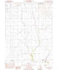 1982 Villa Grove NW1983 Print · USGSThe Champaign and Douglas County line comes alive in the early eighties as the local rail-and-river economy persists. Trace family roots and rural landmarks from Jessee Cem to the tracks of the Norfolk and Western in Philo and Tolono.
 - 1983 Map of Tolono
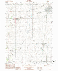 1983 Tolono1983 Print · USGSChampaign County prairie life centered on the rail junctions of Tolono and Sadorus in the early 1980s. Genealogists can trace numerous local burial grounds including Rock Cem and Nelson Cem while exploring the rural reaches of Grange (Jimtown).
 - 1985 Map of Decatur
 1985 Decatur1985 Print · USGSCentral Illinois farming and rail hubs thrive in the mid-1980s as Decatur anchors a sprawling network of track and timber. Trace the paths of the Sangamon River and the Illinois Central Gulf RR through old towns like Cerro Gordo and Bement.2 unique versions available
 - 1985 Map of Champaign, 1986 Print
 1985 Champaign1986 Print · USGSThe Illinois prairie comes alive in this mid-eighties survey of the vital rail corridor between Bloomington and Champaign. Genealogists and historians can trace the development of township hubs like Saybrook and Bellflower or locate Chanute Air Force Base and the Sangamon River.2 unique versions available
End of results
Showing maps 1-4 of 4
Top cities near Tolono
- Champaign historical maps
- Urbana historical maps
- Mahomet historical maps
- Savoy historical maps
- Tuscola historical maps
- Villa Grove historical maps
See more
Frequently asked questions
- What are the different types of historical maps available for Tolono?
- What is the oldest map of Tolono?
- Where can I purchase historical maps of Tolono for my home or office?
- Where can I download high-res historical maps of Tolono?
- Are there historical topographic maps available for Tolono?
- Is there historical aerial imagery available for Tolono?
- Where are historical maps of Tolono sourced from?