1900s (20th Century) Maps of Clarksdale, Illinois
Explore 7 historic maps of Clarksdale from the 1900s (20th Century). These maps offer a rare glimpse into what life looked like during the 1900s — showing old roads, neighborhoods, homes, and landmarks that have changed or disappeared over time.
Whether you're researching your family's past, planning a metal detecting trip, or studying how Clarksdale's landscape evolved across the 1900s, these high-resolution maps are a powerful tool for exploring the history of this region.
- Focus on a specific era: All maps on this page are from the 1900s, giving you a focused view of this time period.
- See what’s changed: Compare century-old streets, trails, and buildings to today's modern landscape using overlays and satellite layers.
- Research with precision: Use these maps for genealogy, historical research, land use analysis, or educational projects.
- View, download, or print: Maps are fully viewable online in high resolution, and can be downloaded or printed for your own records.
Start exploring Clarksdale's history through authentic maps from the 1900s. This is your window into the past.
Clarksdale, IL maps
(7)- 1946 Map of Nokomis, 1965 Print
 1946 Nokomis1965 Print · USGSThe Illinois prairie south of Taylorville reached its industrial and agricultural peak just after World War II. Genealogists can trace family names across dozens of rural sites, including Mound Chapel, D'Arcy Sch, and the mining corridor near Coalton.2 unique versions available
 - 1949 Map of Nokomis
 1949 Nokomis1949 Print · USGSCentral Illinois rail and agricultural life are captured here in the late 1940s, showing the intricate network of country schools and family cemeteries. Genealogists can locate family sites near St Maurice Cem or trace the many local schoolhouses like Mound Sch and Prosperity Sch.2 unique versions available
 - 1958 Map of Decatur, 1971 Print
 1958 Decatur1971 Print · USGSCentral Illinois in the mid-twentieth century shows a landscape defined by industrial rail hubs and the creation of large reservoirs. Researchers can trace historic corridors like the Penn Central or locate landmarks such as Lincoln Log Cabin State Park and Lake Springfield.3 unique versions available
 - 1961 Map of Decatur
 1961 Decatur1961 Print · USGSCentral Illinois in the late fifties was a bustling corridor of rail lines and prairie commerce centered on the state capital. Genealogists and historians can trace the intricate connections between Springfield, Decatur, and dozens of smaller settlements like Nokomis and Arcola.2 unique versions available
 - 1979 Map of Clarksdale, 1980 Print
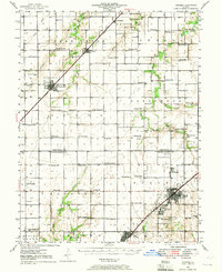
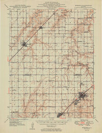
 1979 Clarksdale1980 Print · USGSChristian County farmland meets the waters of the Sangamon River during the late seventies. Researchers can trace the Norfolk and Western rail line through Clarksdale or locate family sites at Brush Creek Cem and Providence Ch.2 unique versions available
 - 1982 Map of Litchfield
 1982 Litchfield1982 Print · USGSThe coal and rail corridors of Central Illinois are captured here in the early eighties as the region balanced industrial mining with its agricultural roots. Researchers can trace family history through sites like Zelmer Memorial Cemetery or the grounds of Blackburn College and the Crown Mine No 1.
 - 1998 Map of Clarksdale, 2002 Print
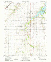
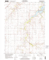 1998 Clarksdale2002 Print · USGSAgricultural Christian County enters the late nineties as the waters of Lake Taylorville reshape the eastern landscape. Trace family roots at Anderson Cem and Vanderville or locate rural hubs like Providence Ch.
End of results
Showing maps 1-7 of 7
Top cities near Clarksdale
- Springfield historical maps
- Taylorville historical maps
- Nokomis historical maps
- Pawnee historical maps
- Kincaid historical maps
- Edinburg historical maps
See more
Frequently asked questions
- What are the different types of historical maps available for Clarksdale?
- What is the oldest map of Clarksdale?
- Where can I purchase historical maps of Clarksdale for my home or office?
- Where can I download high-res historical maps of Clarksdale?
- Are there historical topographic maps available for Clarksdale?
- Is there historical aerial imagery available for Clarksdale?
- Where are historical maps of Clarksdale sourced from?