1980s Maps of Morrisonville, Illinois
Explore 2 historic maps of Morrisonville from the 1980s. These maps offer a rare glimpse into what life looked like during the 1980s — showing old roads, neighborhoods, homes, and landmarks that have changed or disappeared over time.
Whether you're researching your family's past, planning a metal detecting trip, or studying how Morrisonville's landscape evolved across the 1980s, these high-resolution maps are a powerful tool for exploring the history of this region.
- Focus on a specific era: All maps on this page are from the 1980s, giving you a focused view of this time period.
- See what’s changed: Compare century-old streets, trails, and buildings to today's modern landscape using overlays and satellite layers.
- Research with precision: Use these maps for genealogy, historical research, land use analysis, or educational projects.
- View, download, or print: Maps are fully viewable online in high resolution, and can be downloaded or printed for your own records.
Start exploring Morrisonville's history through authentic maps from the 1980s. This is your window into the past.
Morrisonville, IL maps
(2)- 1980 Map of Morrisonville
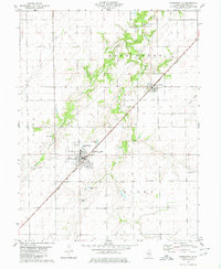 1980 Morrisonville1980 Print · USGSMorrisonville and Palmer thrive along the Norfolk and Western railroad in the early 1980s. Local researchers can trace family roots at several rural burial sites, including St Maurice Cem, Durbin Cem, and Morrisonville Cem.2 unique versions available
 - 1982 Map of Litchfield
 1982 Litchfield1982 Print · USGSThe coal and rail corridors of Central Illinois are captured here in the early eighties as the region balanced industrial mining with its agricultural roots. Researchers can trace family history through sites like Zelmer Memorial Cemetery or the grounds of Blackburn College and the Crown Mine No 1.
End of results
Showing maps 1-2 of 2
Top cities near Morrisonville
- Taylorville historical maps
- Chatham historical maps
- Litchfield historical maps
- Hillsboro historical maps
- Nokomis historical maps
- Pawnee historical maps
See more
Frequently asked questions
- What are the different types of historical maps available for Morrisonville?
- What is the oldest map of Morrisonville?
- Where can I purchase historical maps of Morrisonville for my home or office?
- Where can I download high-res historical maps of Morrisonville?
- Are there historical topographic maps available for Morrisonville?
- Is there historical aerial imagery available for Morrisonville?
- Where are historical maps of Morrisonville sourced from?