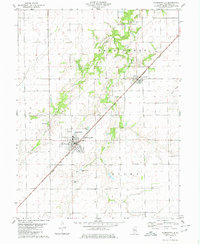
1980 Map of Morrisonville
USGS Topo · Published 1980About this map
The agricultural landscape of Christian County is defined here by the confluence of numerous waterways, including Bear Creek and Prairie Fork, which carve through the prairie towards the Norfolk and Western rail line. The village of Morrisonville serves as the primary hub, showing a structured grid of streets, a sewage disposal system, and the small Trulock Lake at its northern edge. This 1980 survey illustrates the proximity of civic life to the surrounding farms, with several family and community burial sites such as St Maurice Cem and Morrisonville Cem located just outside the residential limits.
Find a feature on this map
18 named features on this map. Tap any name to fly to it.
Don’t see what you’re looking for? This feature index may not catch every label — zoom into the map to look around manually.
Map Details
Editions of this 1980 Morrisonville Map
2 editions found
Other maps of this area

1922 · Divernon
USGS Topo · 1:62,500

1923 · Taylorville
USGS Topo · 1:62,500

1923 · Raymond
USGS Topo · 1:62,500

1924 · Divernon
USGS Topo · 1:62,500

1925 · Taylorville
USGS Topo · 1:62,500

1925 · Raymond
USGS Topo · 1:62,500

1946 · Nokomis
USGS Topo · 1:62,500

1949 · Nokomis
USGS Topo · 1:62,500

1958 · Decatur
USGS Topo · 1:250,000

1961 · Decatur
USGS Topo · 1:250,000