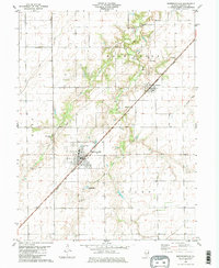
1980 Map of Morrisonville
USGS Topo · Published 1980About this map
Morrisonville and Palmer anchor this survey of south-central Illinois, where the grid of rural township roads meets the diagonal cut of the Norfolk and Western railroad. The landscape is defined by its watercourses, including the winding Prairie Fork and Bear Creek, which disrupt the otherwise orderly agricultural sections. Significant for local family historians, the sheet identifies several remote burial grounds such as Durbin Cem, Anderson Cem, and St Maurice Cem, many located well away from the primary villages. The presence of Trulock Lake and municipal infrastructure like the Sewage Disposal Pond near the village limits illustrates the mid-century development of local utilities and water management in King and Ricks townships.
Find a feature on this map
17 named features on this map. Tap any name to fly to it.
Don’t see what you’re looking for? This feature index may not catch every label — zoom into the map to look around manually.
Map Details
Editions of this 1980 Morrisonville Map
2 editions found
Other maps of this area

1922 · Divernon
USGS Topo · 1:62,500

1923 · Taylorville
USGS Topo · 1:62,500

1923 · Raymond
USGS Topo · 1:62,500

1924 · Divernon
USGS Topo · 1:62,500

1925 · Taylorville
USGS Topo · 1:62,500

1925 · Raymond
USGS Topo · 1:62,500

1946 · Nokomis
USGS Topo · 1:62,500

1949 · Nokomis
USGS Topo · 1:62,500

1958 · Decatur
USGS Topo · 1:250,000

1961 · Decatur
USGS Topo · 1:250,000