1940s Maps of Clark County, Illinois
Explore 7 historic maps of Clark County from the 1940s. These maps offer a rare glimpse into what life looked like during the 1940s — showing old roads, neighborhoods, homes, and landmarks that have changed or disappeared over time.
Whether you're researching your family's past, planning a metal detecting trip, or studying how Clark County's landscape evolved across the 1940s, these high-resolution maps are a powerful tool for exploring the history of this region.
- Focus on a specific era: All maps on this page are from the 1940s, giving you a focused view of this time period.
- See what’s changed: Compare century-old streets, trails, and buildings to today's modern landscape using overlays and satellite layers.
- Research with precision: Use these maps for genealogy, historical research, land use analysis, or educational projects.
- View, download, or print: Maps are fully viewable online in high resolution, and can be downloaded or printed for your own records.
Start exploring Clark County's history through authentic maps from the 1940s. This is your window into the past.
Clark County, IL maps
(7)- 1940 Map of Greenup, 1958 Print
 1940 Greenup1958 Print · USGSCumberland and Jasper Counties are shown in detail as they appeared just before the war, dominated by the winding valley of the Embarrass River. Genealogists can trace dozens of country schools and churches, including Scotch Chapel Sch, Hazel Dell, and Washington Cem.2 unique versions available
 - 1942 Map of Fairbanks
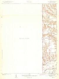
 1942 Fairbanks1942 Print · USGSSullivan County, Indiana, is captured here in the early 1940s as a landscape of river-bend farms and historic family plots. Genealogists and local historians can trace the Harrison Trail or locate ancestral sites like Pogue Cem, Johnson Cem, and the York Ferry river crossing.2 unique versions available
 - 1942 Map of Hutton
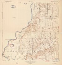
 1942 Hutton1942 Print · USGSThe Indiana-Illinois borderlands along the Wabash River are captured here in the early 1940s, showing a landscape of bayous and ferries. Researchers can trace historic river crossings at Darwin Ferry and locate family burial sites at Shattuck Cem and Lykens Cem.2 unique versions available
 - 1942 Map of Dennison
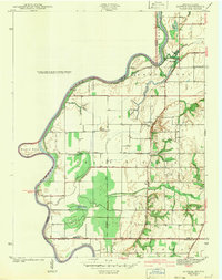
 1942 Dennison1942 Print · USGSThe Illinois-Indiana border comes alive in the early 1940s as the high bluffs of Clark County descend toward the Wabash River. Genealogists and local historians can trace the rural landscape of South Vigo and old routes like National Road and Darwin Road.2 unique versions available
 - 1942 Map of Casey, 1965 Print
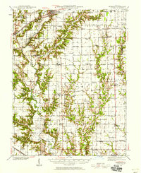
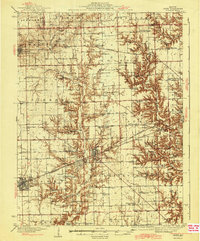
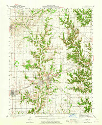 1942 Casey1965 Print · USGSEast-central Illinois comes to life in this mid-century survey of the rail and road networks connecting Casey and Martinsville. Genealogists can trace family legacies through numerous landmarks like Enlow Cem, Willis Chapel, and School No 3.2 unique versions available
 - 1943 Map of Greenup
 1943 Greenup1943 Print · USGSCumberland and Jasper counties are captured here in the early 1940s, highlighting a landscape defined by the Embarrass River and the historic National Road. Researchers can locate dozens of rural schools and family landmarks, from Hunt City to the Washington Cem and Wade Sch.2 unique versions available
 - 1943 Map of Casey
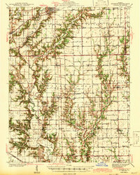
 1943 Casey1943 Print · USGSEastern Illinois during the late thirties and early forties reveals a landscape of railroad towns and emerging oil infrastructure. Genealogists and researchers can trace dozens of rural landmarks, from the Abraham Lincoln Sch to the industrial TANK FARM and the Airway Beacon near Martinsville.2 unique versions available
End of results
Showing maps 1-7 of 7
Top cities of Clark County
- Casey historical maps
- Marshall historical maps
- Martinsville historical maps
- Westfield historical maps
- York historical maps
- Melrose historical maps
See more
Frequently asked questions
- What are the different types of historical maps available for Clark County?
- What is the oldest map of Clark County?
- Where can I purchase historical maps of Clark County for my home or office?
- Where can I download high-res historical maps of Clark County?
- Are there historical topographic maps available for Clark County?
- Is there historical aerial imagery available for Clark County?
- Where are historical maps of Clark County sourced from?