1980s Maps of Clark County, Illinois
Explore 11 historic maps of Clark County from the 1980s. These maps offer a rare glimpse into what life looked like during the 1980s — showing old roads, neighborhoods, homes, and landmarks that have changed or disappeared over time.
Whether you're researching your family's past, planning a metal detecting trip, or studying how Clark County's landscape evolved across the 1980s, these high-resolution maps are a powerful tool for exploring the history of this region.
- Focus on a specific era: All maps on this page are from the 1980s, giving you a focused view of this time period.
- See what’s changed: Compare century-old streets, trails, and buildings to today's modern landscape using overlays and satellite layers.
- Research with precision: Use these maps for genealogy, historical research, land use analysis, or educational projects.
- View, download, or print: Maps are fully viewable online in high resolution, and can be downloaded or printed for your own records.
Start exploring Clark County's history through authentic maps from the 1980s. This is your window into the past.
Clark County, IL maps
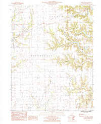
(11)- 1984 Map of Westfield West, 1985 Print
 1984 Westfield West1985 Print · USGSThe rural borderlands of Coles and Clark counties come to life in the early 1980s, showing a landscape defined by prairie farmsteads and river bluffs. Researchers can trace family history through numerous CEM sites and the remote reaches of Embarras River and Hurricane Creek.
 - 1984 Map of Clarksville, 1985 Print
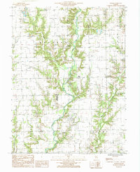
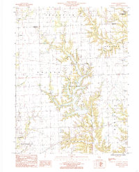 1984 Clarksville1985 Print · USGSClark County in the early eighties shows a rural landscape increasingly shaped by the reservoir at Mill Creek County Park. Genealogists and historians can trace local family landmarks near Clarksville, Doyles, and several rural Cem locations.
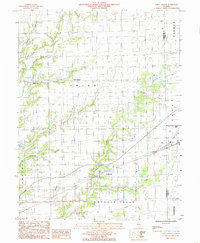
 - 1984 Map of Casey, 1985 Print
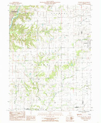
 1984 Casey1985 Print · USGSClark County life in the early eighties centers on the prairie corridor between the towns of Casey and Martinsville. Researchers can trace industrial landmarks like the large Quarry and Gravel Pit or locate family roots near the North Fork Embarras River.
 - 1984 Map of Westfield East, 1985 Print
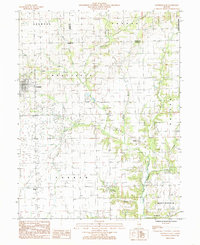 1984 Westfield East1985 Print · USGSThe rural borderlands of Clark, Coles, and Edgar Counties are captured here in the mid-1980s. Local researchers can trace the roads and waterways around Westfield, the legacy of energy extraction at Oilfield, and numerous family burial sites marked simply as Cem.
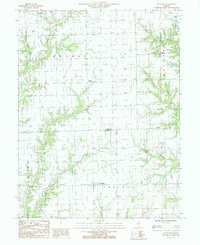
 - 1984 Map of Clark Center, 1985 Print
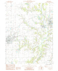
 1984 Clark Center1985 Print · USGSMid-1980s Clark County is captured here as a landscape of rural townships and winding creek bottoms. Genealogists and local historians can trace family locations near Clark Center, Auburn, and Weir, or follow the wooded banks of Hurricane Creek.
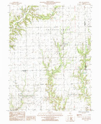
 - 1984 Map of Union Center, 1985 Print
 1984 Union Center1985 Print · USGSCumberland County's rural townships are shown in the early 1980s as a landscape of small settlements and emerging industry. Trace local family history and land use near Union Center, Vevay Park, and the active Oil Field.
 - 1985 Map of Annapolis
 1985 Annapolis1985 Print · USGSNear the Clark and Crawford county line in the 1980s, this area showcases the intersection of Illinois prairie farming and energy production. Researchers can trace rural lineages through the Annapolis townsite and Melrose or locate the extensive Oil Field near Orange.
 - 1985 Map of Hazel Dell
 1985 Hazel Dell1985 Print · USGSCumberland County’s rural landscape is captured in the mid-1980s, documenting the small settlements and local industry of east-central Illinois. Genealogists and researchers can trace family lands near Hazel Dell, locate isolated Oil Wells, and follow the banks of Crooked Creek.
 - 1985 Map of Moriah
 1985 Moriah1985 Print · USGSEastern Illinois farm country and the triple-county border of Clark, Jasper, and Crawford are captured here in the mid-1980s. Genealogists and local historians can trace small rural communities like Moonshine, Hogue Town, and Bellair along the North Fork Embarras River.
 - 1986 Map of Effingham
 1986 Effingham1986 Print · USGSCentral Illinois during the mid-eighties was a hub of rail travel and water recreation centered on the new reservoirs. Genealogists and historians can trace the rural landscape between Mattoon and Effingham, locating landmarks like St Paul Ch and Eagle Creek State Park.2 unique versions available
 - 1986 Map of Terre Haute
 1986 Terre Haute1986 Print · USGSThe Wabash River valley and the coal-rich hills of West-Central Indiana and East-Central Illinois are shown here in the mid-eighties. Genealogists and local historians can trace family-named corners like Barrick Corner, find rural churches like New Hope Ch, and locate industrial landmarks such as the Thunderbird Mine.2 unique versions available
End of results
Showing maps 1-11 of 11
Top cities of Clark County
- Casey historical maps
- Marshall historical maps
- Martinsville historical maps
- Westfield historical maps
- York historical maps
- Melrose historical maps
See more
Frequently asked questions
- What are the different types of historical maps available for Clark County?
- What is the oldest map of Clark County?
- Where can I purchase historical maps of Clark County for my home or office?
- Where can I download high-res historical maps of Clark County?
- Are there historical topographic maps available for Clark County?
- Is there historical aerial imagery available for Clark County?
- Where are historical maps of Clark County sourced from?