1960s Maps of Clark County, Illinois
Explore 8 historic maps of Clark County from the 1960s. These maps offer a rare glimpse into what life looked like during the 1960s — showing old roads, neighborhoods, homes, and landmarks that have changed or disappeared over time.
Whether you're researching your family's past, planning a metal detecting trip, or studying how Clark County's landscape evolved across the 1960s, these high-resolution maps are a powerful tool for exploring the history of this region.
- Focus on a specific era: All maps on this page are from the 1960s, giving you a focused view of this time period.
- See what’s changed: Compare century-old streets, trails, and buildings to today's modern landscape using overlays and satellite layers.
- Research with precision: Use these maps for genealogy, historical research, land use analysis, or educational projects.
- View, download, or print: Maps are fully viewable online in high resolution, and can be downloaded or printed for your own records.
Start exploring Clark County's history through authentic maps from the 1960s. This is your window into the past.
Clark County, IL maps
(8)- 1961 Map of Decatur
 1961 Decatur1961 Print · USGSCentral Illinois in the late fifties was a bustling corridor of rail lines and prairie commerce centered on the state capital. Genealogists and historians can trace the intricate connections between Springfield, Decatur, and dozens of smaller settlements like Nokomis and Arcola.2 unique versions available
 - 1962 Map of Indianapolis
 1962 Indianapolis1962 Print · USGSCentral Indiana and the Illinois borderlands are captured here in the early sixties, showing the region's dense rail networks and growing urban centers. Genealogists and historians can locate family-named landmarks and institutions like Crown Hill Cem, Indiana University, and the Indianapolis Motor Speedway.
 - 1964 Map of Marshall, 1965 Print
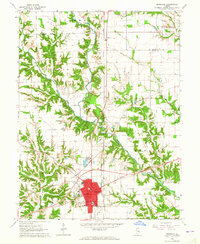 1964 Marshall1965 Print · USGSMarshall and the surrounding Clark County countryside are captured here in the mid-1960s as a bustling crossroads of rail and road. Researchers can trace local lineage through sites like Laufman Cem, visit the town's Fairground, or follow the historic Lincoln Heritage Trail.2 unique versions available
 - 1964 Map of Dennison, 1965 Print
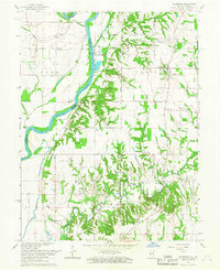
 1964 Dennison1965 Print · USGSThe Illinois-Indiana borderlands appear here in the mid-1960s, centered on the railroad towns and the fertile Wabash Valley. Genealogists and local historians can trace family locations near Ferris Cem, Dennison, and the rural Mt Moriah Ch.3 unique versions available
 - 1964 Map of Hutton, 1965 Print
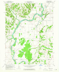 1964 Hutton1965 Print · USGSThe Wabash River valley on the Illinois-Indiana border comes to life in the mid-1960s, showing a landscape defined by river crossings and rural industry. Researchers can trace family history through sites like the Darwin Ferry, Cooper Chapel, and the Shattuck Cem.3 unique versions available
 - 1964 Map of Snyder, 1965 Print
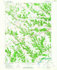
 1964 Snyder1965 Print · USGSSoutheastern Illinois in the early sixties is shown here as a landscape of deeply carved creek valleys and quiet rural junctions. Researchers can trace the New York Central rail line through Ernst and locate local landmarks like Knott Cem and Grand Turn.2 unique versions available
 - 1966 Map of West Union, 1967 Print
 1966 West Union1967 Print · USGSIn the mid-1960s, the rural borderlands between Illinois and Indiana were defined by the New York Central rail line and the winding Wabash River. Researchers can trace family roots at Hogue Cem or Harrison Cem and locate historic community centers like West York and Ohio Chapel.
 - 1966 Map of Fairbanks, 1967 Print
 1966 Fairbanks1967 Print · USGSSullivan County, Indiana and across the Wabash into Illinois are captured here in the late sixties, showcasing a landscape of river-bottom industry and ancient history. Researchers can locate numerous family cemeteries like Pound Cem and Pogue Cem, or trace the infrastructure of the local Oil Field.2 unique versions available
End of results
Showing maps 1-8 of 8
Top cities of Clark County
- Casey historical maps
- Marshall historical maps
- Martinsville historical maps
- Westfield historical maps
- York historical maps
- Melrose historical maps
See more
Frequently asked questions
- What are the different types of historical maps available for Clark County?
- What is the oldest map of Clark County?
- Where can I purchase historical maps of Clark County for my home or office?
- Where can I download high-res historical maps of Clark County?
- Are there historical topographic maps available for Clark County?
- Is there historical aerial imagery available for Clark County?
- Where are historical maps of Clark County sourced from?