1900s (20th Century) Maps of Breese, Illinois
Explore 10 historic maps of Breese from the 1900s (20th Century). These maps offer a rare glimpse into what life looked like during the 1900s — showing old roads, neighborhoods, homes, and landmarks that have changed or disappeared over time.
Whether you're researching your family's past, planning a metal detecting trip, or studying how Breese's landscape evolved across the 1900s, these high-resolution maps are a powerful tool for exploring the history of this region.
- Focus on a specific era: All maps on this page are from the 1900s, giving you a focused view of this time period.
- See what’s changed: Compare century-old streets, trails, and buildings to today's modern landscape using overlays and satellite layers.
- Research with precision: Use these maps for genealogy, historical research, land use analysis, or educational projects.
- View, download, or print: Maps are fully viewable online in high resolution, and can be downloaded or printed for your own records.
Start exploring Breese's history through authentic maps from the 1900s. This is your window into the past.
Breese, IL maps
(10)- 1906 Map of Breese, 1958 Print
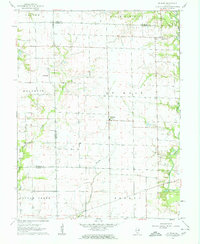
 1906 Breese1958 Print · USGSThe Illinois prairie east of St. Louis is shown here at the turn of the century, when rail lines and rural school districts formed the backbone of local life. Genealogy researchers can locate dozens of country schools like Linden School and Ruth School near established towns like Breese and Germantown.
 - 1907 Map of Breese
 1907 Breese1907 Print · USGSClinton and St. Clair counties were a bustling network of rail-towns and rural school districts at the turn of the century. Researchers can trace ancestral property near dozens of family-named landmarks like Richter School, McKee School, or the small village of Damiansville.2 unique versions available
 - 1910 Map of Carlyle
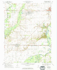
 1910 Carlyle1910 Print · USGSClinton County and the Kaskaskia River valley are captured here at a peak of rural development in the Edwardian era. Genealogists can trace a dense network of family-named landmarks including Hull School, McKendree Chapel, and the river crossing at Colmers Ferry.2 unique versions available
 - 1948 Map of Carlyle
 1948 Carlyle1948 Print · USGSCarlyle and the Kaskaskia River valley are captured in the late 1940s, showing a landscape of river-bend lakes and thriving rail towns. Researchers can trace the heritage of local families at McKendree Chapel, The Mound School, and the State Fish Hatchery.
 - 1958 Map of Belleville, 1973 Print
 1958 Belleville1973 Print · USGSSouthern Illinois during the mid-twentieth century reveals a landscape of industrial growth and massive new reservoirs. Genealogists and historians can trace the paths of the Illinois Central RR through towns like Centralia or locate landmarks such as Emerald Mound and the Looking Glass Prairie.3 unique versions available
 - 1962 Map of Belleville
 1962 Belleville1962 Print · USGSSouthern Illinois in the late fifties reveals a landscape of industrial growth and ancient landmarks before the full expansion of the interstate system. Genealogists can trace family names and rural post offices near Centralia, Salem, and the historic Monks Mound.
 - 1962 Map of St. Rose, 1963 Print
 1962 St. Rose1963 Print · USGSThe rural borderlands of Clinton and Madison counties are captured here in the early sixties. Researchers can locate the Lake Branch Cemetery, the small cluster of Sebastopol, and early property lines near Shoal Creek.2 unique versions available
 - 1962 Map of Breese, 1963 Print
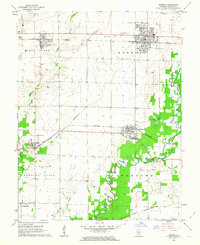 1962 Breese1963 Print · USGSClinton County’s rural and rail landscape is captured here in the early sixties as small towns flourished along the dual rail lines. Genealogists and historians can trace family roots at St Dominics Cem, Damiansville, and the grounds of Mater Dei High Sch.2 unique versions available
 - 1969 Map of Beckemeyer, 1971 Print
 1969 Beckemeyer1971 Print · USGSClinton County thrived as a center for rail, oil, and river trade in the late sixties. Genealogists and local historians can trace family plots at Beckemeyer Cem or St Cecelias Cem while exploring the Bartelso Oil Field and river bottomlands.
 - 1985 Map of Carlyle Lake
 1985 Carlyle Lake1985 Print · USGSSouthwestern Illinois in the mid-eighties shows a landscape of growing commuter suburbs and massive water management projects. Genealogists and historians can locate family plots at Lakeview Memorial Gardens Cem or trace the early footprint of Southern Illinois Univ (Edwardsville).2 unique versions available
End of results
Showing maps 1-10 of 10
Top cities near Breese
- Highland historical maps
- Carlyle historical maps
- New Baden historical maps
- Nashville historical maps
- Trenton historical maps
- Aviston historical maps
See more
Frequently asked questions
- What are the different types of historical maps available for Breese?
- What is the oldest map of Breese?
- Where can I purchase historical maps of Breese for my home or office?
- Where can I download high-res historical maps of Breese?
- Are there historical topographic maps available for Breese?
- Is there historical aerial imagery available for Breese?
- Where are historical maps of Breese sourced from?