1920s Maps of Austin, Chicago
Explore 4 historic maps of Austin from the 1920s. These maps offer a rare glimpse into what life looked like during the 1920s — showing old roads, neighborhoods, homes, and landmarks that have changed or disappeared over time.
Whether you're researching your family's past, planning a metal detecting trip, or studying how Austin's landscape evolved across the 1920s, these high-resolution maps are a powerful tool for exploring the history of this region.
- Focus on a specific era: All maps on this page are from the 1920s, giving you a focused view of this time period.
- See what’s changed: Compare century-old streets, trails, and buildings to today's modern landscape using overlays and satellite layers.
- Research with precision: Use these maps for genealogy, historical research, land use analysis, or educational projects.
- View, download, or print: Maps are fully viewable online in high resolution, and can be downloaded or printed for your own records.
Start exploring Austin's history through authentic maps from the 1920s. This is your window into the past.
Austin, Chicago maps
(4)- 1928 Map of Berwyn
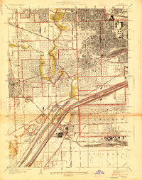 1928 Berwyn1928 Print · USGSThe suburban expansion west of Chicago is in full swing in the late twenties as industrial and rail networks reshape the land. Trace family history at Waldheim Cemetery or explore early aviation at the Maywood U S Mail Airport.3 unique versions available
 - 1928 Map of River Forest
 1928 River Forest1928 Print · USGSIn the late twenties, the Chicago city limits pushed westward toward the Des Plaines River, transforming prairie and farmland into a dense suburban grid. Genealogists and historians can trace family plots in St Joseph Cemetery or locate early landmarks like Rosary College and the Chicago State Hospital.4 unique versions available
 - 1929 Map of Englewood
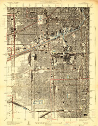 1929 Englewood1929 Print · USGSThe South Side of Chicago in the mid-twenties shows a landscape transformed by heavy industry and rail transport. Genealogy and local history researchers can trace the dense grid around the Union Stock Yards, Englewood, and the sprawling Corwith Yards.3 unique versions available
 - 1929 Map of Chicago Loop, 1939 Print
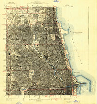 1929 Chicago Loop1939 Print · USGSChicago and its lakefront are captured here between the world wars, showing a city defined by its rigid grid and grand public parks. Genealogists and historians can trace old neighborhoods near Rose Hill Cemetery, the grounds of Loyola University, or the original layout of the Municipal Pier.2 unique versions available
End of results
Showing maps 1-4 of 4
Frequently asked questions
- What are the different types of historical maps available for Austin?
- What is the oldest map of Austin?
- Where can I purchase historical maps of Austin for my home or office?
- Where can I download high-res historical maps of Austin?
- Are there historical topographic maps available for Austin?
- Is there historical aerial imagery available for Austin?
- Where are historical maps of Austin sourced from?