1920s Maps of Lake Township, Chicago
Explore 5 historic maps of Lake Township from the 1920s. These maps offer a rare glimpse into what life looked like during the 1920s — showing old roads, neighborhoods, homes, and landmarks that have changed or disappeared over time.
Whether you're researching your family's past, planning a metal detecting trip, or studying how Lake Township's landscape evolved across the 1920s, these high-resolution maps are a powerful tool for exploring the history of this region.
- Focus on a specific era: All maps on this page are from the 1920s, giving you a focused view of this time period.
- See what’s changed: Compare century-old streets, trails, and buildings to today's modern landscape using overlays and satellite layers.
- Research with precision: Use these maps for genealogy, historical research, land use analysis, or educational projects.
- View, download, or print: Maps are fully viewable online in high resolution, and can be downloaded or printed for your own records.
Start exploring Lake Township's history through authentic maps from the 1920s. This is your window into the past.
Lake Township, Chicago maps
(5)- 1928 Map of Berwyn
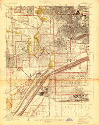 1928 Berwyn1928 Print · USGSThe suburban expansion west of Chicago is in full swing in the late twenties as industrial and rail networks reshape the land. Trace family history at Waldheim Cemetery or explore early aviation at the Maywood U S Mail Airport.3 unique versions available
 - 1929 Map of Calumet Lake
 1929 Calumet Lake1929 Print · USGSThe industrial heart of the South Side and the Indiana borderlands comes alive in this survey of the Calumet region. Genealogists and historians can trace the streets of Pullman, the extensive rail yards of the Belt Ry of Chicago, and early features like the Pullman Training School.3 unique versions available
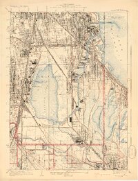
 - 1929 Map of Blue Island
 1929 Blue Island1929 Print · USGSSouth Chicago and its suburbs are captured in the late twenties during a period of rapid industrial and rail expansion. Genealogists can trace family plots across Mt Hope and Oak Hill, or locate local landmarks like Bremen School and Blue Island.3 unique versions available
 - 1929 Map of Jackson Park
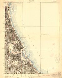 1929 Jackson Park1929 Print · USGSThe South Side of Chicago during the late 1920s reveals a sophisticated network of grand parks and lakefront landmarks. Genealogists and urban historians can trace the grid from Oakwoods Cemetery to iconic sites like Soldiers Field and the Field Museum.3 unique versions available
 - 1929 Map of Englewood
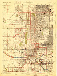
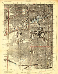 1929 Englewood1929 Print · USGSThe South Side of Chicago in the mid-twenties shows a landscape transformed by heavy industry and rail transport. Genealogy and local history researchers can trace the dense grid around the Union Stock Yards, Englewood, and the sprawling Corwith Yards.3 unique versions available
End of results
Showing maps 1-5 of 5
Top cities near Lake Township
- Chicago historical maps
- Cicero historical maps
- Hammond historical maps
- Oak Lawn historical maps
- Berwyn historical maps
- Orland Park historical maps
See more
Top neighborhoods of Lake Township
- Chicago Lawn historical maps
- Auburn Gresham historical maps
- New City historical maps
- Ashburn historical maps
- Gage Park historical maps
- Garfield Ridge historical maps
See more
Frequently asked questions
- What are the different types of historical maps available for Lake Township?
- What is the oldest map of Lake Township?
- Where can I purchase historical maps of Lake Township for my home or office?
- Where can I download high-res historical maps of Lake Township?
- Are there historical topographic maps available for Lake Township?
- Is there historical aerial imagery available for Lake Township?
- Where are historical maps of Lake Township sourced from?