1960s Maps of Lake Township, Chicago
Explore 6 historic maps of Lake Township from the 1960s. These maps offer a rare glimpse into what life looked like during the 1960s — showing old roads, neighborhoods, homes, and landmarks that have changed or disappeared over time.
Whether you're researching your family's past, planning a metal detecting trip, or studying how Lake Township's landscape evolved across the 1960s, these high-resolution maps are a powerful tool for exploring the history of this region.
- Focus on a specific era: All maps on this page are from the 1960s, giving you a focused view of this time period.
- See what’s changed: Compare century-old streets, trails, and buildings to today's modern landscape using overlays and satellite layers.
- Research with precision: Use these maps for genealogy, historical research, land use analysis, or educational projects.
- View, download, or print: Maps are fully viewable online in high resolution, and can be downloaded or printed for your own records.
Start exploring Lake Township's history through authentic maps from the 1960s. This is your window into the past.
Lake Township, Chicago maps
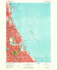
(6)- 1960 Map of Lake Calumet, 1962 Print
 1960 Lake Calumet1962 Print · USGSThe industrial south side of Chicago and the Indiana borderlands meet in this early 1960s survey. Genealogists and historians can trace neighborhood evolution through parish schools like Our Lady of Hungary Sch, early housing at Altgeld Gardens, and the heavy rail lines of the Pennsylvania RR.
 - 1963 Map of Jackson Park, 1964 Print
 1963 Jackson Park1964 Print · USGSThe Chicago lakefront in the early sixties showcases a dense urban landscape defined by major cultural landmarks and rail corridors. Researchers can trace the mid-century South Side grid near the University of Chicago, Oak Woods Cemetery, and the historic Meigs Field.3 unique versions available
 - 1963 Map of Berwyn, 1965 Print
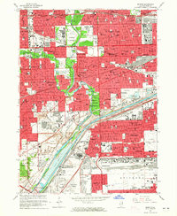 1963 Berwyn1965 Print · USGSThe western Chicago suburbs are seen here in the mid-sixties as post-war industrial and residential growth peaks. Local historians can trace family roots through the dense cemetery district or locate long-standing landmarks like Morton Jr College and the Chicago Zoological Park.3 unique versions available
 - 1963 Map of Blue Island, 1965 Print
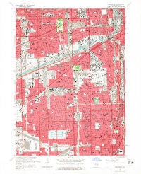
 1963 Blue Island1965 Print · USGSSouth of Chicago in the early sixties, these burgeoning suburbs grew around a massive network of rail lines and industrial canals. Researchers can trace the footprints of numerous parochial schools, family burial plots in Mt Olivet Cemetery, and landmarks like the Evergreen Plaza Shopping Center.3 unique versions available
 - 1963 Map of Englewood, 1965 Print
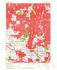
 1963 Englewood1965 Print · USGSThe South Side of Chicago and Cicero are seen here in the mid-sixties, a period defined by the rise of the great expressways and dense rail corridors. Genealogists and local historians can trace parish life and neighborhoods through sites like St Rita High Sch, Elsdon, and the International Amphitheatre.4 unique versions available
 - 1965 Map of Lake Calumet, 1966 Print
 1965 Lake Calumet1966 Print · USGSSoutheast Chicago and the Indiana borderlands were a powerhouse of rail and industry in the mid-sixties. Researchers can trace historic parish life and neighborhood growth through sites like Altgeld Gardens, Hegewisch, and the Chicago Vocational Sch.4 unique versions available
End of results
Showing maps 1-6 of 6
Top cities near Lake Township
- Chicago historical maps
- Cicero historical maps
- Hammond historical maps
- Oak Lawn historical maps
- Berwyn historical maps
- Orland Park historical maps
See more
Top neighborhoods of Lake Township
- Chicago Lawn historical maps
- Auburn Gresham historical maps
- New City historical maps
- Ashburn historical maps
- Gage Park historical maps
- Garfield Ridge historical maps
See more
Frequently asked questions
- What are the different types of historical maps available for Lake Township?
- What is the oldest map of Lake Township?
- Where can I purchase historical maps of Lake Township for my home or office?
- Where can I download high-res historical maps of Lake Township?
- Are there historical topographic maps available for Lake Township?
- Is there historical aerial imagery available for Lake Township?
- Where are historical maps of Lake Township sourced from?