1990s Maps of Lake Township, Chicago
Explore 10 historic maps of Lake Township from the 1990s. These maps offer a rare glimpse into what life looked like during the 1990s — showing old roads, neighborhoods, homes, and landmarks that have changed or disappeared over time.
Whether you're researching your family's past, planning a metal detecting trip, or studying how Lake Township's landscape evolved across the 1990s, these high-resolution maps are a powerful tool for exploring the history of this region.
- Focus on a specific era: All maps on this page are from the 1990s, giving you a focused view of this time period.
- See what’s changed: Compare century-old streets, trails, and buildings to today's modern landscape using overlays and satellite layers.
- Research with precision: Use these maps for genealogy, historical research, land use analysis, or educational projects.
- View, download, or print: Maps are fully viewable online in high resolution, and can be downloaded or printed for your own records.
Start exploring Lake Township's history through authentic maps from the 1990s. This is your window into the past.
Lake Township, Chicago maps
(10)- 1991 Map of Lake Calumet, 1992 Print
 1991 Lake Calumet1992 Print · USGSChicago's industrial southeast side and the Indiana borderlands are captured here at a time of heavy rail and river transit. Genealogists can locate family-named neighborhoods and parish schools like St Michael Sch, Robertsdale, and Altgeld Gardens.
 - 1993 Map of Englewood
 1993 Englewood1993 Print · USGSChicago's southwestern neighborhoods are captured here in the early nineties, showing a landscape defined by heavy rail and industrial canals. Researchers can trace local history through the many neighborhood institutions like the International Amphitheatre, Maria High Sch, and the rail hub at Elsdon.2 unique versions available
 - 1993 Map of Berwyn
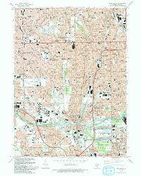
 1993 Berwyn1993 Print · USGSThe western suburbs of Chicago and the busy Des Plaines riverfront are captured here in the early nineties. Genealogists and researchers can trace local landmarks like Waldheim Cemetery, the Brookfield Zoo, and the Hines VA Hospital.2 unique versions available
 - 1993 Map of Jackson Park
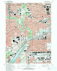
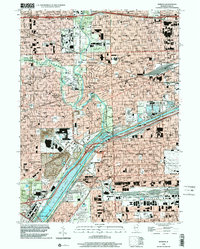
 1993 Jackson Park1993 Print · USGSThe South Side of Chicago and its iconic lakefront are captured here in the early nineties, showcasing a high-density urban grid of schools, hospitals, and parks. Researchers can trace the layout of the University of Chicago campus or locate family plots in the expansive Oakwoods Cemetery.
 - 1993 Map of Blue Island
 1993 Blue Island1993 Print · USGSThe south side of Chicago and its neighboring suburbs are shown in the early nineties as a mature urban landscape. Researchers can trace family sites near St Casimir Cemetery and Burr Oak Cemetery or locate historic institutions like Morgan Park Academy.2 unique versions available
 - 1997 Map of Lake Calumet, 1999 Print
 1997 Lake Calumet1999 Print · USGSThe industrial heart of the South Side and Northwest Indiana comes alive in this late-twentieth-century study of the Calumet region. Genealogists and researchers can trace neighborhood landmarks from Hegewisch to Robertsdale, including numerous parochial schools like St Kevin Sch and the legacy of Altgeld Gardens.
 - 1997 Map of Englewood, 1999 Print
 1997 Englewood1999 Print · USGSChicago during the late 1990s reveals a complex network of industrial canals and historic neighborhood centers. Genealogists and urban historians can trace community roots through numerous parish schools like St Gall Sch and landmarks such as the Cook County Dept of Corrections.
 - 1997 Map of Blue Island, 1999 Print
 1997 Blue Island1999 Print · USGSThe southern Chicago suburbs and Blue Island are captured here in the late nineties, showing a landscape of dense residential grids and massive cemeteries. Researchers can trace historic boundaries like the Old Indian Boundary or locate institutions like St Xavier College and Burr Oak Cemetery.
 - 1998 Map of Jackson Park, 1999 Print
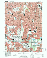
 1998 Jackson Park1999 Print · USGSThe Chicago lakefront at the close of the twentieth century reveals a dense network of South Side neighborhoods and iconic public spaces. Genealogists and historians can locate dozens of institutions, from Oakwoods Cemetery to the campus of Meigs Field and Soldier Field.
 - 1998 Map of Berwyn, 2002 Print
 1998 Berwyn2002 Print · USGSCook County's industrial and residential heart is captured here during the late twentieth century as the western suburbs reached full maturity. Researchers can trace the massive cemetery complexes like Waldheim Cemetery and aviation landmarks such as Midway Airport.
End of results
Showing maps 1-10 of 10
Top cities near Lake Township
- Chicago historical maps
- Cicero historical maps
- Hammond historical maps
- Oak Lawn historical maps
- Berwyn historical maps
- Orland Park historical maps
See more
Top neighborhoods of Lake Township
- Chicago Lawn historical maps
- Auburn Gresham historical maps
- New City historical maps
- Ashburn historical maps
- Gage Park historical maps
- Garfield Ridge historical maps
See more
Frequently asked questions
- What are the different types of historical maps available for Lake Township?
- What is the oldest map of Lake Township?
- Where can I purchase historical maps of Lake Township for my home or office?
- Where can I download high-res historical maps of Lake Township?
- Are there historical topographic maps available for Lake Township?
- Is there historical aerial imagery available for Lake Township?
- Where are historical maps of Lake Township sourced from?