1980s Maps of Elk Grove Township, Illinois
Explore 4 historic maps of Elk Grove Township from the 1980s. These maps offer a rare glimpse into what life looked like during the 1980s — showing old roads, neighborhoods, homes, and landmarks that have changed or disappeared over time.
Whether you're researching your family's past, planning a metal detecting trip, or studying how Elk Grove Township's landscape evolved across the 1980s, these high-resolution maps are a powerful tool for exploring the history of this region.
- Focus on a specific era: All maps on this page are from the 1980s, giving you a focused view of this time period.
- See what’s changed: Compare century-old streets, trails, and buildings to today's modern landscape using overlays and satellite layers.
- Research with precision: Use these maps for genealogy, historical research, land use analysis, or educational projects.
- View, download, or print: Maps are fully viewable online in high resolution, and can be downloaded or printed for your own records.
Start exploring Elk Grove Township's history through authentic maps from the 1980s. This is your window into the past.
Elk Grove Township, IL maps
(4)- 1980 Map of Chicago
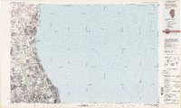
 1980 Chicago1980 Print · USGSThe Chicago metropolitan area and the industrial shores of Northwest Indiana are captured here at the start of the 1980s. Genealogists and local historians can trace the vast urban landscape through landmarks like Loyola University, St Casimir Cemetery, and the busy docks of Calumet Harbor.
 - 1980 Map of Waukegan
 1980 Waukegan1980 Print · USGSThe Illinois North Shore and Lake Michigan coastline appear at a point of high development in the early eighties. Trace the expansive grounds of the Great Lakes Naval Training Center, Fort Sheridan, and historic Northwestern University.
 - 1981 Map of Elgin
 1981 Elgin1981 Print · USGSNorthern Illinois and southern Wisconsin are shown in the early eighties as suburban growth meets glacial terrain. Trace the paths of the Milwaukee Road through Harvard or explore the wetlands of Volo Bog State Natural Area.
 - 1985 Map of Aurora, 1989 Print
 1985 Aurora1989 Print · USGSNortheastern Illinois is captured in the mid-1980s as suburban growth began to bridge the gap between the Fox River cities and the outer prairies. Researchers can trace the development of Naperville and Aurora or locate rural landmarks like Fairview Cem and the Illinois and Michigan Canal.
End of results
Showing maps 1-4 of 4
Top cities near Elk Grove Township
- Chicago historical maps
- Naperville historical maps
- Cicero historical maps
- Schaumburg historical maps
- Arlington Heights historical maps
- Palatine historical maps
See more
Top neighborhoods of Elk Grove Township
Frequently asked questions
- What are the different types of historical maps available for Elk Grove Township?
- What is the oldest map of Elk Grove Township?
- Where can I purchase historical maps of Elk Grove Township for my home or office?
- Where can I download high-res historical maps of Elk Grove Township?
- Are there historical topographic maps available for Elk Grove Township?
- Is there historical aerial imagery available for Elk Grove Township?
- Where are historical maps of Elk Grove Township sourced from?