1950s Maps of Lyons Township, Illinois
Explore 6 historic maps of Lyons Township from the 1950s. These maps offer a rare glimpse into what life looked like during the 1950s — showing old roads, neighborhoods, homes, and landmarks that have changed or disappeared over time.
Whether you're researching your family's past, planning a metal detecting trip, or studying how Lyons Township's landscape evolved across the 1950s, these high-resolution maps are a powerful tool for exploring the history of this region.
- Focus on a specific era: All maps on this page are from the 1950s, giving you a focused view of this time period.
- See what’s changed: Compare century-old streets, trails, and buildings to today's modern landscape using overlays and satellite layers.
- Research with precision: Use these maps for genealogy, historical research, land use analysis, or educational projects.
- View, download, or print: Maps are fully viewable online in high resolution, and can be downloaded or printed for your own records.
Start exploring Lyons Township's history through authentic maps from the 1950s. This is your window into the past.
Lyons Township, IL maps
(6)- 1953 Map of Palos Park, 1955 Print
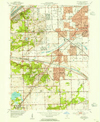 1953 Palos Park1955 Print · USGSMid-century Cook County shows a landscape of expansive forest preserves and industrial waterways just as residential growth began to accelerate. Genealogists and local historians can trace family plots at Holy Sepulchre Cemetery or locate the long-since changed Harlem Airport and Bachelor Grove Cem.
 - 1953 Map of Sag Bridge, 1955 Print
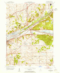 1953 Sag Bridge1955 Print · USGSThe Des Plaines River valley transitions from industrial canal corridors to preserved forest land in the early fifties. Genealogists and historians can locate family plots at Mount Vernon Memorial Park Cemetery and trace old school districts like Derby Sch and Trinity Sch.2 unique versions available
 - 1953 Map of Hinsdale, 1956 Print
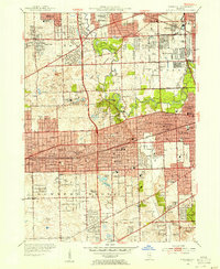 1953 Hinsdale1956 Print · USGSMid-century DuPage and Cook counties show a landscape of growing suburbs and extensive country clubs linked by several major rail lines. Genealogists and local historians can trace family plots at Clarendon Hills Cemetery or locate the old Hinsdale Airport and Township Jr College.
 - 1953 Map of Berwyn, 1956 Print
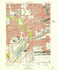 1953 Berwyn1956 Print · USGSWestern Cook County thrives as a mid-century industrial and transport hub, where dense residential blocks meet massive rail yards and canals. Genealogists can locate family sites across the Jewish Cemeteries or trace neighborhood landmarks like Morton Junior College and Stinson Airport.
 - 1953 Map of Chicago, 1964 Print
 1953 Chicago1964 Print · USGSThe southern Lake Michigan shoreline was rapidly modernizing in the mid-fifties, balancing heavy industry with its famous academic centers. Researchers can trace the footprints of Notre Dame University or locate vanished sites like the Kingsbury Ordnance Plant and Meigs Field.5 unique versions available
 - 1957 Map of Chicago
 1957 Chicago1957 Print · USGSThe industrial heartland and southern Great Lakes shoreline are captured here during the peak of mid-century growth. Researchers can trace the massive Gary Steel Works, the grounds of the University of Notre Dame, and the early paths of the Tri-State Tollway.
End of results
Showing maps 1-6 of 6
Top cities near Lyons Township
- Chicago historical maps
- Joliet historical maps
- Cicero historical maps
- Schaumburg historical maps
- Bolingbrook historical maps
- Oak Lawn historical maps
See more
Top neighborhoods of Lyons Township
- Lyons historical maps
- La Grange Highlands historical maps
- La Grange historical maps
- Western Springs historical maps
- Justice historical maps
- Summit historical maps
See more
Frequently asked questions
- What are the different types of historical maps available for Lyons Township?
- What is the oldest map of Lyons Township?
- Where can I purchase historical maps of Lyons Township for my home or office?
- Where can I download high-res historical maps of Lyons Township?
- Are there historical topographic maps available for Lyons Township?
- Is there historical aerial imagery available for Lyons Township?
- Where are historical maps of Lyons Township sourced from?