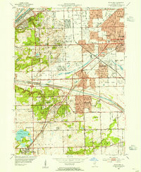
1953 Map of Palos Park
USGS Topo · Published 1955About this map
Palos Hills Forest Preserve and Argonne Forest Preserve provide a massive green belt through this suburbanizing landscape, featuring distinctive wetlands like Pollywog Slough and Belly Deep Slough. The region is defined by the industrial and transport engineering of the Chicago Sanitary and Ship Canal and the Calumet Sag Channel, which cross the terrain alongside the Wabash and Chicago Belt Terminal railroads. This mid-century view captures the transition of the Illinois prairie into residential communities, documented through numerous neighborhood schools like St Albert Sch and Sandburg High Sch. Extensive burial grounds, including the massive Holy Sepulchre Cemetery and the isolated Bachelor Grove Cem, underscore the area's role as a major regional cemetery hub. Near Chicago Ridge and Worth, the Harlem Airport and a Drive-in Theater highlight the era's reliance on aviation and automotive culture.
Find a feature on this map
69 named features on this map. Tap any name to fly to it.
Don’t see what you’re looking for? This feature index may not catch every label — zoom into the map to look around manually.
Map Details
Editions of this 1953 Palos Park Map
This is the sole edition of this map. No revisions or reprints were ever made.
Other maps of this area

1889 · Chicago
USGS Topo · 1:62,500

1890 · Des Plaines
USGS Topo · 1:62,500

1891 · Chicago
USGS Topo · 1:62,500

1891 · Riverside
USGS Topo · 1:62,500

1892 · Calumet
USGS Topo · 1:62,500

1893 · Calumet
USGS Topo · 1:62,500

1893 · Riverside
USGS Topo · 1:62,500

1894 · Des Plaines
USGS Topo · 1:62,500

1900 · Chicago
USGS Topo · 1:62,500

1900 · Des Plaines
USGS Topo · 1:62,500