1894 Map of Des Plaines
USGS Topo · Published 1894About this map
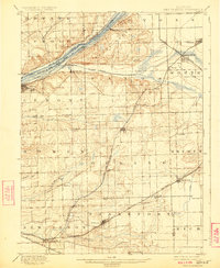
The Des Plaines River corridor serves as the industrial and transit spine of this 1890s landscape, flanked by the historic Illinois and Michigan Canal and a dense network of competing railroads. This era of surveying by D.C. Harrison reveals the transition from rural townships to a series of connected railroad stops and small canal towns. The Chicago and Alton R. R. and Atchison Topeka and Santa Fe R. R. follow the water’s edge, linking early industrial hubs like Lemont and Willow Springs.
Find a feature on this map
41 named features on this map. Tap any name to fly to it.
Don’t see what you’re looking for? This feature index may not catch every label — zoom into the map to look around manually.
Map Details
Editions of this 1894 Des Plaines Map
This is the sole edition of this map. No revisions or reprints were ever made.
Historical Maps of Joliet Through Time
4 maps found