1890 Map of Des Plaines
USGS Topo · Published 1890About this map
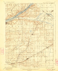
The Des Plaines River valley serves as the primary corridor for transportation and settlement in this late nineteenth-century survey. Parallel to the river, the Illinois and Michigan Canal and the Chicago and Alton Canal illustrate the critical role of waterway engineering in the region's development. Small railroad outposts and settlements like Lemont, Willow Springs, and Sag Station dot the northern corridor, while the southern reaches show a transition toward more isolated villages including Orland and Mokena.
Find a feature on this map
39 named features on this map. Tap any name to fly to it.
Don’t see what you’re looking for? This feature index may not catch every label — zoom into the map to look around manually.
Map Details
Editions of this 1890 Des Plaines Map
This is the sole edition of this map. No revisions or reprints were ever made.
Historical Maps of Joliet Through Time
4 maps found