
1900 Map of Chicago
USGS Topo · Published 1900About this map
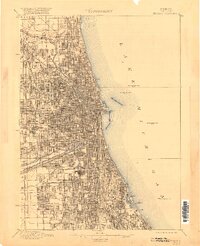
Lake Michigan dominates the eastern boundary of this turn-of-the-century Chicago landscape, which reveals a metropolis defined by its intensive water and rail engineering. The dual channels of the Illinois and Michigan Canal and the Sanitary and Ship Canal carve through the southwest, running parallel to a dense concentration of railroads including the Illinois Central R. R. and the Chicago and Alton R. R. This network of transportation and sanitation infrastructure facilitated the city's rapid expansion into outlying districts such as Chicago Lawn, Mayfair, and Auburn Park. In contrast to the industrial corridors, the map delineates large civic green spaces like Jackson Park and Washington Park in the south, while major burial grounds including Rose Hill Cemetery and Graceland Cem. are established in the north, providing a clear view of the city's planned residential and commercial growth during the late Victorian era.
Find a feature on this map
31 named features on this map. Tap any name to fly to it.
Don’t see what you’re looking for? This feature index may not catch every label — zoom into the map to look around manually.
Map Details
Editions of this 1900 Chicago Map
This is the sole edition of this map. No revisions or reprints were ever made.
Historical Maps of Chicago Through Time
7 maps found


Featured Locations
- Chicago, IL
- Cicero, IL
- Lincolnwood, Niles Township
- Burbank, Stickney Township
- Stickney, Stickney Township