
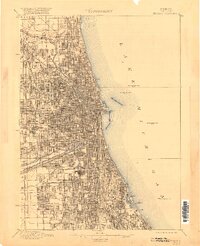
1889 Map of Chicago
USGS Topo · Published 1889About this map
The dense industrial and transport hub of Chicago is revealed here just before the dawn of the 1890s, defined by its intricate grid and massive rail infrastructure. The city's geography is anchored by the North Branch Chicago River and South Branch Chicago River, which converge and flow toward the expansive Lake Michigan shoreline. This map captures the city when it was the premier rail crossroads of the nation, showing a staggering concentration of lines including the Chicago Milwaukee and St. Paul R.R. and the Chicago Burlington and Quincy R.R.. Beyond the natural waterways, the Illinois and Michigan Canal appears as a critical link for commerce. This survey by D.C. Harrison under Director J. W. Powell documents the urban footprint during a period of explosive growth, illustrating how the rail corridors shaped the development of the city's neighborhoods and harbor.
Find a feature on this map
19 named features on this map. Tap any name to fly to it.
Don’t see what you’re looking for? This feature index may not catch every label — zoom into the map to look around manually.
Map Details
Editions of this 1889 Chicago Map
This is the sole edition of this map. No revisions or reprints were ever made.
Historical Maps of Chicago Through Time
7 maps found


Featured Locations
- Chicago, IL
- Cicero, IL
- Lincolnwood, Niles Township
- Burbank, Stickney Township
- Stickney, Stickney Township