1950s Maps of Glenview, Northfield Township
Explore 3 historic maps of Glenview from the 1950s. These maps offer a rare glimpse into what life looked like during the 1950s — showing old roads, neighborhoods, homes, and landmarks that have changed or disappeared over time.
Whether you're researching your family's past, planning a metal detecting trip, or studying how Glenview's landscape evolved across the 1950s, these high-resolution maps are a powerful tool for exploring the history of this region.
- Focus on a specific era: All maps on this page are from the 1950s, giving you a focused view of this time period.
- See what’s changed: Compare century-old streets, trails, and buildings to today's modern landscape using overlays and satellite layers.
- Research with precision: Use these maps for genealogy, historical research, land use analysis, or educational projects.
- View, download, or print: Maps are fully viewable online in high resolution, and can be downloaded or printed for your own records.
Start exploring Glenview's history through authentic maps from the 1950s. This is your window into the past.
Glenview, Northfield Township maps
(3)- 1953 Map of Arlington Heights, 1955 Print
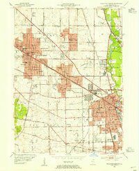 1953 Arlington Heights1955 Print · USGSPost-war Cook County comes alive in this survey of the growing corridor from Arlington Heights to Des Plaines. Trace family roots at All Saints Cem or locate the early footprints of Pal-Waukee Airport and O'Hare Field.
 - 1953 Map of Park Ridge, 1956 Print
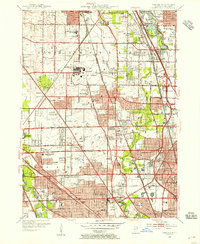 1953 Park Ridge1956 Print · USGSThe northern Chicago suburbs are caught in a moment of rapid post-war suburbanization during the early fifties. Genealogists and local historians can trace family roots through numerous sites like Sunset Memorial Gardens, Maine Township High Sch, and the St Andrews Home.
 - 1958 Map of Racine, 1971 Print
 1958 Racine1971 Print · USGSThe Lake Michigan shoreline in the late fifties was a study in contrasts between the industrial bustle of Kenosha and the quiet woods of the Allegan State Forest. Genealogists and historians can trace the urban footprint of Evanston or locate strategic sites like Fort Sheridan and the Wind Point Light.3 unique versions available
End of results
Showing maps 1-3 of 3
Top cities near Glenview
- Chicago historical maps
- Waukegan historical maps
- Cicero historical maps
- Schaumburg historical maps
- Arlington Heights historical maps
- Evanston historical maps
See more
Top neighborhoods of Glenview
- Northfield Woods historical maps
- Landings at the Glen historical maps
- Chapel Crossing in the Glen historical maps
- Tall Trees historical maps
- Southgate at The Glen historical maps
- Swainwood historical maps
Frequently asked questions
- What are the different types of historical maps available for Glenview?
- What is the oldest map of Glenview?
- Where can I purchase historical maps of Glenview for my home or office?
- Where can I download high-res historical maps of Glenview?
- Are there historical topographic maps available for Glenview?
- Is there historical aerial imagery available for Glenview?
- Where are historical maps of Glenview sourced from?