1920s Maps of Northbrook, Northfield Township
Explore 4 historic maps of Northbrook from the 1920s. These maps offer a rare glimpse into what life looked like during the 1920s — showing old roads, neighborhoods, homes, and landmarks that have changed or disappeared over time.
Whether you're researching your family's past, planning a metal detecting trip, or studying how Northbrook's landscape evolved across the 1920s, these high-resolution maps are a powerful tool for exploring the history of this region.
- Focus on a specific era: All maps on this page are from the 1920s, giving you a focused view of this time period.
- See what’s changed: Compare century-old streets, trails, and buildings to today's modern landscape using overlays and satellite layers.
- Research with precision: Use these maps for genealogy, historical research, land use analysis, or educational projects.
- View, download, or print: Maps are fully viewable online in high resolution, and can be downloaded or printed for your own records.
Start exploring Northbrook's history through authentic maps from the 1920s. This is your window into the past.
Northbrook, Northfield Township maps
(4)- 1927 Map of Arlington Heights
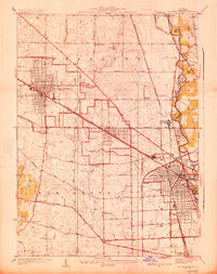 1927 Arlington Heights1927 Print · USGSCook County in the mid-1920s shows a landscape of emerging rail suburbs and quiet prairie farmland. Genealogists and local historians can trace family-named sites and vanished landmarks like the English Cemetery, Schnells Corner, and St Johns Church.3 unique versions available
 - 1928 Map of Wheeling
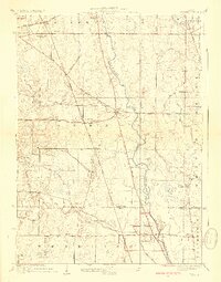 1928 Wheeling1928 Print · USGSNortheastern Illinois appears in the mid-twenties as a landscape of rural schoolhouses and expanding rail lines along the Des Plaines River. Genealogists and local historians can locate early landmarks like Diamond Lake Cemetery, Tripp School, and the settlement of Aptakisic.4 unique versions available
 - 1928 Map of Highland Park
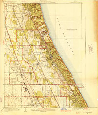 1928 Highland Park1928 Print · USGSThe North Shore was entering a golden age of suburban development and leisure in the late twenties. Trace the expansion of Highland Park and Lake Forest through their numerous estate clubs and historic schools like Lake Forest Academy.4 unique versions available
 - 1929 Map of Park Ridge
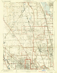 1929 Park Ridge1929 Print · USGSNorth of Chicago in the late twenties, this area was rapidly evolving from agricultural land into a network of suburban settlements. Genealogists and historians can trace institutional sites like the St Marys Mission House and early cemeteries such as Maine Cemetery or Sunset Cemetery.3 unique versions available
End of results
Showing maps 1-4 of 4
Top cities near Northbrook
- Chicago historical maps
- Waukegan historical maps
- Schaumburg historical maps
- Arlington Heights historical maps
- Evanston historical maps
- Palatine historical maps
See more
Top neighborhoods of Northbrook
- Williamsburg Square historical maps
- Fair Meadows historical maps
- Lee Acres historical maps
- Northbrook Manor historical maps
- White Plains historical maps
- Northbrook Park historical maps
See more
Frequently asked questions
- What are the different types of historical maps available for Northbrook?
- What is the oldest map of Northbrook?
- Where can I purchase historical maps of Northbrook for my home or office?
- Where can I download high-res historical maps of Northbrook?
- Are there historical topographic maps available for Northbrook?
- Is there historical aerial imagery available for Northbrook?
- Where are historical maps of Northbrook sourced from?