1960s Maps of Orland Park, Orland Township
Explore 4 historic maps of Orland Park from the 1960s. These maps offer a rare glimpse into what life looked like during the 1960s — showing old roads, neighborhoods, homes, and landmarks that have changed or disappeared over time.
Whether you're researching your family's past, planning a metal detecting trip, or studying how Orland Park's landscape evolved across the 1960s, these high-resolution maps are a powerful tool for exploring the history of this region.
- Focus on a specific era: All maps on this page are from the 1960s, giving you a focused view of this time period.
- See what’s changed: Compare century-old streets, trails, and buildings to today's modern landscape using overlays and satellite layers.
- Research with precision: Use these maps for genealogy, historical research, land use analysis, or educational projects.
- View, download, or print: Maps are fully viewable online in high resolution, and can be downloaded or printed for your own records.
Start exploring Orland Park's history through authentic maps from the 1960s. This is your window into the past.
Orland Park, Orland Township maps
(4)- 1963 Map of Sag Bridge, 1964 Print
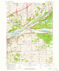 1963 Sag Bridge1964 Print · USGSIn the early 1960s, the Cook County landscape was a complex mix of industrial canals, dense forest preserves, and expanding suburbs. Trace the legacy of Lemont and Willow Springs alongside the Chicago Sanitary and Ship Canal and historic Fairmount Cemetery.3 unique versions available
 - 1963 Map of Mokena, 1964 Print
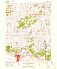 1963 Mokena1964 Print · USGSWill County in the early sixties shows the steady growth of rail-connected villages alongside deep-rooted rural communities. Trace the family names and legacy sites at Brooks Cem, follow the Rock Island Line, or locate long-standing schools like Schmuhl Sch.2 unique versions available
 - 1963 Map of Tinley Park, 1964 Print
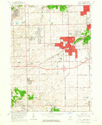 1963 Tinley Park1964 Print · USGSThe Cook and Will County borderlands undergo significant suburban transformation in the early sixties. Researchers can trace the legacy of local institutions and infrastructure, from the Tinley Park State Hospital and Prosperi Airport to the diagonal path of the Indian Boundary Treaty.4 unique versions available
 - 1963 Map of Palos Park, 1965 Print
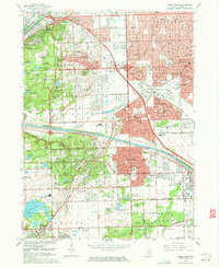 1963 Palos Park1965 Print · USGSCook County's southwestern suburbs and forest preserves are shown here in the early sixties as post-war growth meets industrial waterways. Genealogists and historians can locate dozens of schools and significant burial sites like Holy Sepulchre Cemetery and the local landmark Bachelor Grove Cem.5 unique versions available
End of results
Showing maps 1-4 of 4
Top cities near Orland Park
- Chicago historical maps
- Joliet historical maps
- Cicero historical maps
- Bolingbrook historical maps
- Oak Lawn historical maps
- Berwyn historical maps
See more
Top neighborhoods of Orland Park
Frequently asked questions
- What are the different types of historical maps available for Orland Park?
- What is the oldest map of Orland Park?
- Where can I purchase historical maps of Orland Park for my home or office?
- Where can I download high-res historical maps of Orland Park?
- Are there historical topographic maps available for Orland Park?
- Is there historical aerial imagery available for Orland Park?
- Where are historical maps of Orland Park sourced from?