1920s Maps of Dolton, Thornton Township
Explore 4 historic maps of Dolton from the 1920s. These maps offer a rare glimpse into what life looked like during the 1920s — showing old roads, neighborhoods, homes, and landmarks that have changed or disappeared over time.
Whether you're researching your family's past, planning a metal detecting trip, or studying how Dolton's landscape evolved across the 1920s, these high-resolution maps are a powerful tool for exploring the history of this region.
- Focus on a specific era: All maps on this page are from the 1920s, giving you a focused view of this time period.
- See what’s changed: Compare century-old streets, trails, and buildings to today's modern landscape using overlays and satellite layers.
- Research with precision: Use these maps for genealogy, historical research, land use analysis, or educational projects.
- View, download, or print: Maps are fully viewable online in high resolution, and can be downloaded or printed for your own records.
Start exploring Dolton's history through authentic maps from the 1920s. This is your window into the past.
Dolton, Thornton Township maps
(4)- 1929 Map of Calumet Lake
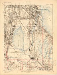 1929 Calumet Lake1929 Print · USGSThe industrial heart of the South Side and the Indiana borderlands comes alive in this survey of the Calumet region. Genealogists and historians can trace the streets of Pullman, the extensive rail yards of the Belt Ry of Chicago, and early features like the Pullman Training School.3 unique versions available
 - 1929 Map of Calumet City
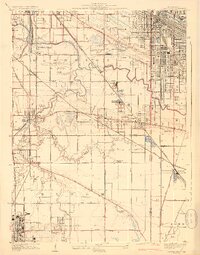 1929 Calumet City1929 Print · USGSThe Calumet region during the late twenties shows a landscape transitioning from rural townships to industrial hubs. Genealogists and historians can trace the early rail networks, numerous family-named cemeteries like Oak Hill Cem, and local landmarks such as the Brickyard and Sunnybrook School.3 unique versions available
 - 1929 Map of Blue Island
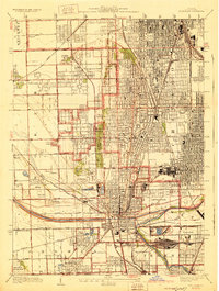 1929 Blue Island1929 Print · USGSSouth Chicago and its suburbs are captured in the late twenties during a period of rapid industrial and rail expansion. Genealogists can trace family plots across Mt Hope and Oak Hill, or locate local landmarks like Bremen School and Blue Island.3 unique versions available
 - 1929 Map of Harvey
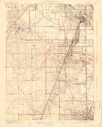 1929 Harvey1929 Print · USGSSouthern Cook County emerges as a major rail and residential hub in the late twenties. Genealogists and historians can trace the development of Markham Yards, find the Glenwood Manual Training School, and locate St Johns Sch and local cemeteries.4 unique versions available
End of results
Showing maps 1-4 of 4
Top cities near Dolton
- Chicago historical maps
- Cicero historical maps
- Hammond historical maps
- Gary historical maps
- Oak Lawn historical maps
- Berwyn historical maps
See more
Top neighborhoods of Dolton
Frequently asked questions
- What are the different types of historical maps available for Dolton?
- What is the oldest map of Dolton?
- Where can I purchase historical maps of Dolton for my home or office?
- Where can I download high-res historical maps of Dolton?
- Are there historical topographic maps available for Dolton?
- Is there historical aerial imagery available for Dolton?
- Where are historical maps of Dolton sourced from?