1990s Maps of Greenup, Illinois
Explore 2 historic maps of Greenup from the 1990s. These maps offer a rare glimpse into what life looked like during the 1990s — showing old roads, neighborhoods, homes, and landmarks that have changed or disappeared over time.
Whether you're researching your family's past, planning a metal detecting trip, or studying how Greenup's landscape evolved across the 1990s, these high-resolution maps are a powerful tool for exploring the history of this region.
- Focus on a specific era: All maps on this page are from the 1990s, giving you a focused view of this time period.
- See what’s changed: Compare century-old streets, trails, and buildings to today's modern landscape using overlays and satellite layers.
- Research with precision: Use these maps for genealogy, historical research, land use analysis, or educational projects.
- View, download, or print: Maps are fully viewable online in high resolution, and can be downloaded or printed for your own records.
Start exploring Greenup's history through authentic maps from the 1990s. This is your window into the past.
Greenup, IL maps
(2)- 1998 Map of Toledo, 2002 Print
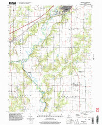
 1998 Toledo2002 Print · USGSCumberland County at the close of the century shows a landscape where the Embarras River winds between established towns and quiet rural townships. Genealogists and historians can trace the Old Railroad Grade or locate family sites near Graveyard Hill and Janesville.
 - 1998 Map of Greenup, 2002 Print
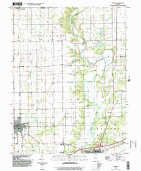
 1998 Greenup2002 Print · USGSCumberland and Jasper counties are captured here in the late twentieth century, showing a landscape defined by the winding Embarras River. Researchers can trace the layout of Greenup and Jewett, locate family plots in numerous cemeteries, and identify the path of the Old Grade and rural outposts like Walla Walla.
End of results
Showing maps 1-2 of 2
Top cities near Greenup
- Charleston historical maps
- Mattoon historical maps
- Casey historical maps
- Toledo historical maps
- Dieterich historical maps
- Hutton historical maps
See more
Frequently asked questions
- What are the different types of historical maps available for Greenup?
- What is the oldest map of Greenup?
- Where can I purchase historical maps of Greenup for my home or office?
- Where can I download high-res historical maps of Greenup?
- Are there historical topographic maps available for Greenup?
- Is there historical aerial imagery available for Greenup?
- Where are historical maps of Greenup sourced from?