1930s Maps of Mayfield Township, Illinois
Explore 4 historic maps of Mayfield Township from the 1930s. These maps offer a rare glimpse into what life looked like during the 1930s — showing old roads, neighborhoods, homes, and landmarks that have changed or disappeared over time.
Whether you're researching your family's past, planning a metal detecting trip, or studying how Mayfield Township's landscape evolved across the 1930s, these high-resolution maps are a powerful tool for exploring the history of this region.
- Focus on a specific era: All maps on this page are from the 1930s, giving you a focused view of this time period.
- See what’s changed: Compare century-old streets, trails, and buildings to today's modern landscape using overlays and satellite layers.
- Research with precision: Use these maps for genealogy, historical research, land use analysis, or educational projects.
- View, download, or print: Maps are fully viewable online in high resolution, and can be downloaded or printed for your own records.
Start exploring Mayfield Township's history through authentic maps from the 1930s. This is your window into the past.
Mayfield Township, IL maps
(4)- 1934 Map of De Kalb, 1965 Print
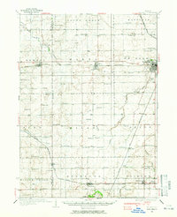 1934 De Kalb1965 Print · USGSDeKalb and its surrounding townships thrive as a major rail and highway hub during the mid-1930s. Researchers can trace dozens of country schoolhouses like Toad Hollow Sch and find family plots at Woodlawn Cem or Fairview Cem.
 - 1937 Map of De Kalb
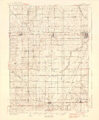 1937 De Kalb1937 Print · USGSMid-1930s De Kalb County is captured here as a thriving rail and agricultural hub during the peak of the Lincoln Highway era. Genealogists can trace family footprints across dozens of local school sites like Toad Hollow Sch and old cemeteries including Woodlawn Cem and Calvary Cem.2 unique versions available
 - 1937 Map of Sycamore
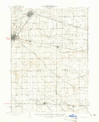 1937 Sycamore1937 Print · USGSDeKalb and Kane counties are captured here in the mid-thirties, showing a landscape defined by prairie agriculture and a bustling rail network. Genealogists can locate family-named landmarks and rural institutions like Ohio Grove Cem, East Pierce Ch, and Coltonville Sch.2 unique versions available
 - 1938 Map of Genoa
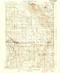 1938 Genoa1938 Print · USGSNorthern Illinois farm country and rail junctions thrive in the late 1930s across the borders of De Kalb and McHenry counties. Genealogists can locate dozens of rural landmarks, from North Kingston Cem and Ney Ch to many local schools like Genoa Center Sch.3 unique versions available
End of results
Showing maps 1-4 of 4
Top cities near Mayfield Township
- Rockford historical maps
- DeKalb historical maps
- Belvidere historical maps
- Sycamore historical maps
- Rochelle historical maps
- Genoa historical maps
See more
Top neighborhoods of Mayfield Township
Frequently asked questions
- What are the different types of historical maps available for Mayfield Township?
- What is the oldest map of Mayfield Township?
- Where can I purchase historical maps of Mayfield Township for my home or office?
- Where can I download high-res historical maps of Mayfield Township?
- Are there historical topographic maps available for Mayfield Township?
- Is there historical aerial imagery available for Mayfield Township?
- Where are historical maps of Mayfield Township sourced from?