1990s Maps of DeWitt County, Illinois
Explore 5 historic maps of DeWitt County from the 1990s. These maps offer a rare glimpse into what life looked like during the 1990s — showing old roads, neighborhoods, homes, and landmarks that have changed or disappeared over time.
Whether you're researching your family's past, planning a metal detecting trip, or studying how DeWitt County's landscape evolved across the 1990s, these high-resolution maps are a powerful tool for exploring the history of this region.
- Focus on a specific era: All maps on this page are from the 1990s, giving you a focused view of this time period.
- See what’s changed: Compare century-old streets, trails, and buildings to today's modern landscape using overlays and satellite layers.
- Research with precision: Use these maps for genealogy, historical research, land use analysis, or educational projects.
- View, download, or print: Maps are fully viewable online in high resolution, and can be downloaded or printed for your own records.
Start exploring DeWitt County's history through authentic maps from the 1990s. This is your window into the past.
DeWitt County, IL maps
(5)- 1990 Map of Peoria
 1990 Peoria1990 Print · USGSCentral Illinois at the start of the nineties reveals a landscape of industrial river towns and sprawling university campuses. Researchers can trace the legacy of major institutions like Chanute Air Force Base and the University of Illinois alongside regional landmarks such as Sand Ridge State Forest.
 - 1998 Map of Heyworth, 2000 Print
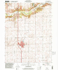
 1998 Heyworth2000 Print · USGSHeyworth and the surrounding McLean County countryside are shown here in the late nineties, defined by the winding Kickapoo Creek and a legacy of rural family homesteads. Genealogists can trace local lineages through numerous burial sites including Old Rutledge Cem, Bishop Cem, and Stewart Cem.
 - 1998 Map of Maroa, 2001 Print
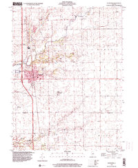
 1998 Maroa2001 Print · USGSMaroa and the surrounding townships in De Witt and Macon Counties are captured here at the end of the twentieth century. Researchers can trace the Illinois Central Railroad corridor, the grounds of Maroa Cem, and the rural Texas Ch.
 - 1999 Map of Clinton, 2001 Print
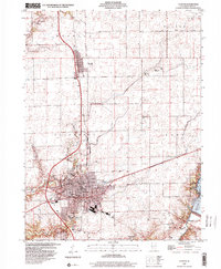 1999 Clinton2001 Print · USGSClinton and the surrounding De Witt County countryside are documented here in the final years of the century. Genealogists and local historians can trace legacy sites like Crum Cem and Prairie Center Ch or explore the early footprint of Weldon Springs State Park.
 - 1999 Map of De Witt, 2003 Print
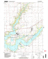 1999 De Witt2003 Print · USGSDe Witt County at the close of the twentieth century shows a landscape transformed by the waters of Clinton Lake. Researchers can locate family burial plots at De Witt Cem and Lisemby Cem alongside the heavy industry of the massive Powerplant.
End of results
Showing maps 1-5 of 5
Top cities of DeWitt County
- Clinton historical maps
- Farmer City historical maps
- Tunbridge historical maps
- Wapella historical maps
- Waynesville historical maps
- Weldon historical maps
See more
Frequently asked questions
- What are the different types of historical maps available for DeWitt County?
- What is the oldest map of DeWitt County?
- Where can I purchase historical maps of DeWitt County for my home or office?
- Where can I download high-res historical maps of DeWitt County?
- Are there historical topographic maps available for DeWitt County?
- Is there historical aerial imagery available for DeWitt County?
- Where are historical maps of DeWitt County sourced from?