1980s Maps of Kemp, Illinois
Explore 2 historic maps of Kemp from the 1980s. These maps offer a rare glimpse into what life looked like during the 1980s — showing old roads, neighborhoods, homes, and landmarks that have changed or disappeared over time.
Whether you're researching your family's past, planning a metal detecting trip, or studying how Kemp's landscape evolved across the 1980s, these high-resolution maps are a powerful tool for exploring the history of this region.
- Focus on a specific era: All maps on this page are from the 1980s, giving you a focused view of this time period.
- See what’s changed: Compare century-old streets, trails, and buildings to today's modern landscape using overlays and satellite layers.
- Research with precision: Use these maps for genealogy, historical research, land use analysis, or educational projects.
- View, download, or print: Maps are fully viewable online in high resolution, and can be downloaded or printed for your own records.
Start exploring Kemp's history through authentic maps from the 1980s. This is your window into the past.
Kemp, IL maps
(2)- 1982 Map of Hindsboro, 1983 Print
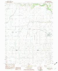 1982 Hindsboro1983 Print · USGSDouglas and Coles counties are shown in the early eighties as the agricultural landscape of East Central Illinois continued to modernize. Researchers can trace rural lineages through the locations of Hindsboro, Kemp, and the Mt Gilead Ch near the Embarras River.
 - 1985 Map of Decatur
 1985 Decatur1985 Print · USGSCentral Illinois farming and rail hubs thrive in the mid-1980s as Decatur anchors a sprawling network of track and timber. Trace the paths of the Sangamon River and the Illinois Central Gulf RR through old towns like Cerro Gordo and Bement.2 unique versions available
End of results
Showing maps 1-2 of 2
Top cities near Kemp
- Charleston historical maps
- Mattoon historical maps
- Tuscola historical maps
- Arcola historical maps
- Villa Grove historical maps
- Oakland historical maps
See more
Frequently asked questions
- What are the different types of historical maps available for Kemp?
- What is the oldest map of Kemp?
- Where can I purchase historical maps of Kemp for my home or office?
- Where can I download high-res historical maps of Kemp?
- Are there historical topographic maps available for Kemp?
- Is there historical aerial imagery available for Kemp?
- Where are historical maps of Kemp sourced from?