Old Maps of Darien, Illinois for Genealogy
Trace your family roots with 58 historic maps of Darien. These high-res maps reveal old neighborhoods, homesites, landmarks, and streets — helping you uncover where your ancestors lived and how the area evolved over time.
- Explore historic neighborhoods: Identify where your relatives may have lived in the 1800s or 1900s.
- Compare maps over time: Trace the changes in streets, buildings, and landmarks for multi-generational research.
- Perfect for genealogy & ancestry research: Used by family historians and researchers to map out lineage and migration.
These maps are an incredible resource for exploring your personal connection to Darien's past.
Darien, IL maps
(58)- 1890 Map of Des Plaines
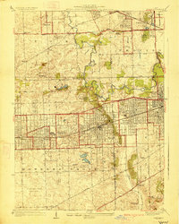
 1890 Des Plaines1890 Print · USGSThe Des Plaines valley and southern Cook County are shown here in the late nineteenth century as a hub of canal and rail transit. Genealogists can trace family roots in early settlements like Lemont, Orland, and Mokena or locate vanished stops like Johnston Station.
 - 1891 Map of Riverside
 1891 Riverside1891 Print · USGSWest of Chicago in the early nineties, these developing suburbs formed a dense network of rail-side settlements and waterworks. Genealogists can trace early homesteads and vanished landmarks like the County Farm and Mammoth Springs alongside the banks of the Des Plaines River.
 - 1892 Map of Joliet
 1892 Joliet1892 Print · USGSWill County at the end of the nineteenth century was a bustling intersection of canal trade and heavy rail. Genealogists can trace the early streets of Joliet and Lockport or locate long-standing rural landmarks like Caton Farm and Grinton.6 unique versions available
 - 1893 Map of Riverside
 1893 Riverside1893 Print · USGSWest of Chicago in the 1890s, the landscape was a growing network of rail-centered villages and industrial canals. Genealogists and local historians can trace early property and town layouts in Riverside, Maywood, and the Dunning County Farm alongside the Desplaines River.
 - 1894 Map of Des Plaines
 1894 Des Plaines1894 Print · USGSCook and Will counties in the 1890s are defined by the convergence of major rail lines and early waterway transit. Genealogists and historians can trace the foundations of Lemont, Mokena, and New Lenox along lines like the Wabash R. R. and the Illinois and Michigan Canal.
 - 1900 Map of Des Plaines
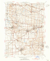
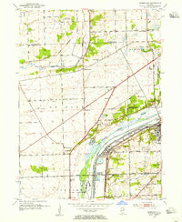
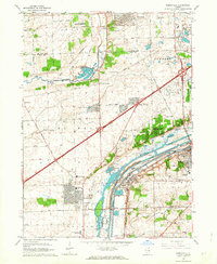
 1900 Des Plaines1900 Print · USGSCook and Will counties at the turn of the century reveal a landscape of massive canal engineering and burgeoning railroad junctions. Researchers can trace ancestral farmsteads and old station stops from Sag Bridge Sta. to the early streets of Tinley Park and Mokena.
 - 1900 Map of Riverside
 1900 Riverside1900 Print · USGSThe western Chicago suburbs and the Desplaines River valley are captured here during a period of massive industrial and rail expansion. Genealogists can locate early settlements like Fullersburg and Lace, or trace family plots in Waldheim Cemetery.
 - 1901 Map of Des Plaines
 1901 Des Plaines1901 Print · USGSCook and Will County communities thrive along a dense network of nineteenth-century canals and rail lines. Genealogists and local historians can trace early property patterns and rail stops in Willow Springs, Tinley Park, and Gooding's Grove.5 unique versions available
 - 1901 Map of Riverside
 1901 Riverside1901 Print · USGSGreater Chicago and the Desplaines River valley are captured here at a moment of rapid rail expansion and civic engineering. Genealogists and historians can trace early settlements and burial sites like Waldheim Cemetery, the Chicago Union Transfer Railroad Yards, and Jefferson Park.4 unique versions available
 - 1908 Map of Wheaton
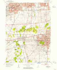
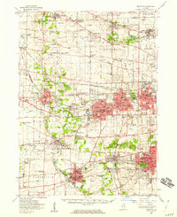
 1908 Wheaton1908 Print · USGSDuPage County was a hub of steam and electric rail travel in the years following the turn of the century. Genealogists and historians can trace the early footprints of Naperville, Downers Grove, and Wheaton, alongside notable sites like the Wheaton Driving Park.5 unique versions available
 - 1923 Map of Joliet
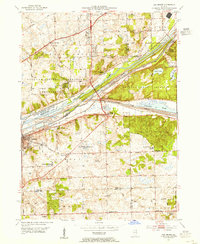
 1923 Joliet1923 Print · USGSJoliet and the Des Plaines River valley are shown here in the 1920s, a hub of heavy industry and vital shipping canals. Genealogists and local historians can trace family roots through numerous country schools like Spaulding School, the Du Page Church, and the expansive State Penitentiary Farm.5 unique versions available
 - 1927 Map of Hinsdale
 1927 Hinsdale1927 Print · USGSThe western Chicago suburbs emerged as a hub of transit and leisure in the late twenties, where rail lines met rising commuter towns. Genealogists can trace family names and institutions from St Joseph Institute to the vanished crossroads of Utopia and Lace.3 unique versions available
 - 1928 Map of Sag Bridge
 1928 Sag Bridge1928 Print · USGSThe Des Plaines valley in the late 1920s reveals a complex network of canals and railways connecting Lemont and Willow Springs. Trace early twentieth-century landmarks like Visitation Boys Camp, Fairmont Cemetery, and the Derby School.4 unique versions available
 - 1948 Map of Wheaton, 1956 Print
 1948 Wheaton1956 Print · USGSDuPage County at the dawn of the post-war boom shows a landscape of growing towns connected by a dense network of steam and electric rails. Researchers can trace the early footprints of Naperville, Wheaton, and Downers Grove alongside smaller stops like Ontarioville and Eola.
 - 1953 Map of Sag Bridge, 1955 Print
 1953 Sag Bridge1955 Print · USGSThe Des Plaines River valley transitions from industrial canal corridors to preserved forest land in the early fifties. Genealogists and historians can locate family plots at Mount Vernon Memorial Park Cemetery and trace old school districts like Derby Sch and Trinity Sch.2 unique versions available
 - 1953 Map of Hinsdale, 1956 Print
 1953 Hinsdale1956 Print · USGSMid-century DuPage and Cook counties show a landscape of growing suburbs and extensive country clubs linked by several major rail lines. Genealogists and local historians can trace family plots at Clarendon Hills Cemetery or locate the old Hinsdale Airport and Township Jr College.
 - 1953 Map of Chicago, 1964 Print
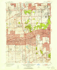
 1953 Chicago1964 Print · USGSThe southern Lake Michigan shoreline was rapidly modernizing in the mid-fifties, balancing heavy industry with its famous academic centers. Researchers can trace the footprints of Notre Dame University or locate vanished sites like the Kingsbury Ordnance Plant and Meigs Field.5 unique versions available
 - 1954 Map of Romeoville, 1955 Print
 1954 Romeoville1955 Print · USGSThe Des Plaines River valley transitions from rural farming to a heavy industrial corridor in the mid-1950s. Genealogists can locate family burial sites at St Alphonsus Cem and Alexander Cem, or trace early schools like Bromberek Sch.
 - 1954 Map of Wheaton, 1955 Print
 1954 Wheaton1955 Print · USGSDuPage County was undergoing significant suburban expansion in the early fifties as transit networks matured. Researchers can locate numerous parochial sites and schools like St Joseph Orphanage, Wheaton College, and Loretto Convent.
 - 1954 Map of Wheaton, 1960 Print
 1954 Wheaton1960 Print · USGSDuPage County transitions from its agricultural roots to a bustling suburban corridor during the mid-fifties. Genealogists and historians can trace institutional landmarks like the Zace Sanitarium, Old Ontarioville Cem, and Sacred Heart Academy before later development.2 unique versions available
 - 1954 Map of Joliet, 1960 Print
 1954 Joliet1960 Print · USGSMid-century Joliet and Plainfield are captured here during a period of heavy industrial and transit growth. Researchers can trace the alignment of the Lincoln Highway and find localized details like the State Prison Farm and Caton Farm.
 - 1957 Map of Chicago
 1957 Chicago1957 Print · USGSThe industrial heartland and southern Great Lakes shoreline are captured here during the peak of mid-century growth. Researchers can trace the massive Gary Steel Works, the grounds of the University of Notre Dame, and the early paths of the Tri-State Tollway.
 - 1958 Map of Aurora, 1969 Print
 1958 Aurora1969 Print · USGSNorthern Illinois in the late fifties shows a landscape of powerful river industry and expanding transport corridors. Genealogists and historians can trace the development of Aurora and Joliet or locate sites like the Elwood Ordnance Plant and Starved Rock.3 unique versions available
 - 1961 Map of Aurora
 1961 Aurora1961 Print · USGSNorthern Illinois at the height of the post-war era reveals a landscape of massive industrial works and thriving river towns. Genealogists and historians can trace the paths of the Lincoln Highway or locate long-standing landmarks like the Green River Ordnance Plant and Starved Rock State Park.
 - 1962 Map of Romeoville, 1963 Print
 1962 Romeoville1963 Print · USGSThe Des Plaines Valley was undergoing significant suburban and industrial expansion in the early sixties. Researchers can trace the development of Romeoville and Lemont or locate local landmarks like Resurrection Cemetery and the Du Page Ch.4 unique versions available
Showing maps 1-25 of 58
Top cities near Darien
- Chicago historical maps
- Aurora historical maps
- Joliet historical maps
- Naperville historical maps
- Cicero historical maps
- Bolingbrook historical maps
See more
Top neighborhoods of Darien
Frequently asked questions
- What are the different types of historical maps available for Darien?
- What is the oldest map of Darien?
- Where can I purchase historical maps of Darien for my home or office?
- Where can I download high-res historical maps of Darien?
- Are there historical topographic maps available for Darien?
- Is there historical aerial imagery available for Darien?
- Where are historical maps of Darien sourced from?