1990s Maps of Lombard, Illinois
Explore 8 historic maps of Lombard from the 1990s. These maps offer a rare glimpse into what life looked like during the 1990s — showing old roads, neighborhoods, homes, and landmarks that have changed or disappeared over time.
Whether you're researching your family's past, planning a metal detecting trip, or studying how Lombard's landscape evolved across the 1990s, these high-resolution maps are a powerful tool for exploring the history of this region.
- Focus on a specific era: All maps on this page are from the 1990s, giving you a focused view of this time period.
- See what’s changed: Compare century-old streets, trails, and buildings to today's modern landscape using overlays and satellite layers.
- Research with precision: Use these maps for genealogy, historical research, land use analysis, or educational projects.
- View, download, or print: Maps are fully viewable online in high resolution, and can be downloaded or printed for your own records.
Start exploring Lombard's history through authentic maps from the 1990s. This is your window into the past.
Lombard, IL maps
(8)- 1993 Map of Hinsdale
 1993 Hinsdale1993 Print · USGSThe western suburbs of Chicago are seen in their late-century maturity, where the residential grids of Hinsdale and La Grange meet major transit corridors. Genealogists and local historians can locate prominent memorial sites like Mt Carmel Cemetery and schools like Bethany Seminary.
 - 1993 Map of Elmhurst
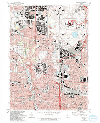 1993 Elmhurst1993 Print · USGSSuburban Chicago thrives in the early nineties, showing the massive footprint of O'Hare International Airport alongside growing residential tracts. Genealogists and historians can trace local landmarks like Elmhurst College, Arlington Cemetery, and York High School.
 - 1993 Map of Lombard
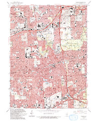
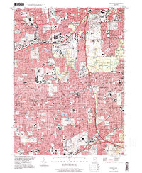
 1993 Lombard1993 Print · USGSDuPage County communities like Lombard and Glen Ellyn are shown in the early nineties during a period of intense suburban maturity. Genealogists and local historians can trace parish sites like St Johns Cem and Sacred Heart Ch alongside the protected grounds of Churchill Woods Co For Presv.
 - 1993 Map of Wheaton, 1994 Print
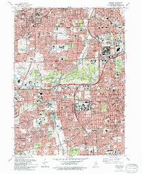 1993 Wheaton1994 Print · USGSDuPage County enters a period of significant suburban density in the early nineties as major transit corridors reshape the landscape. Local historians can trace the growth of Wheaton and Lisle, identifying landmarks like Wheaton College and the Morton Arboretum.
 - 1997 Map of Hinsdale, 1999 Print
 1997 Hinsdale1999 Print · USGSThe western Chicago suburbs are shown here in the late nineties, featuring a landscape of established residential grids and sprawling forest preserves. Researchers can locate dozens of institutions and burial grounds like Queen of Heaven Cemetery, Bethany Seminary, and the historic Fullersburg Cem.
 - 1997 Map of Elmhurst, 1999 Print
 1997 Elmhurst1999 Print · USGSThe western edge of the Chicago suburbs is captured here in the late 1990s as industry and aviation define the landscape. Researchers can trace local institutions and landmarks from Elmhurst College to Mt Emblem Cemetery and York High Sch.
 - 1998 Map of Wheaton, 2002 Print
 1998 Wheaton2002 Print · USGSDuPage County at the turn of the millennium shows a landscape of deep-rooted suburban communities and sprawling green spaces. Genealogists and local historians can locate legacy institutions like Wheaton College, the Wheaton Cemetery, and the Morton Arboretum.
 - 1998 Map of Lombard, 2002 Print
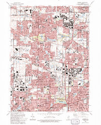
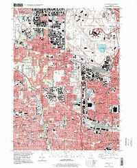
 1998 Lombard2002 Print · USGSDuPage County at the close of the century shows a mature suburban landscape where historic rail hubs meet modern forest preserves. Genealogists and local historians can trace the foundations of Glen Ellyn and Addison via landmarks like St Pauls Cem and the Chicago and North Western railroad.
End of results
Showing maps 1-8 of 8
Top cities near Lombard
- Chicago historical maps
- Aurora historical maps
- Naperville historical maps
- Elgin historical maps
- Schaumburg historical maps
- Arlington Heights historical maps
See more
Top neighborhoods of Lombard
Frequently asked questions
- What are the different types of historical maps available for Lombard?
- What is the oldest map of Lombard?
- Where can I purchase historical maps of Lombard for my home or office?
- Where can I download high-res historical maps of Lombard?
- Are there historical topographic maps available for Lombard?
- Is there historical aerial imagery available for Lombard?
- Where are historical maps of Lombard sourced from?