1990s Maps of Effingham, Illinois
Explore 2 historic maps of Effingham from the 1990s. These maps offer a rare glimpse into what life looked like during the 1990s — showing old roads, neighborhoods, homes, and landmarks that have changed or disappeared over time.
Whether you're researching your family's past, planning a metal detecting trip, or studying how Effingham's landscape evolved across the 1990s, these high-resolution maps are a powerful tool for exploring the history of this region.
- Focus on a specific era: All maps on this page are from the 1990s, giving you a focused view of this time period.
- See what’s changed: Compare century-old streets, trails, and buildings to today's modern landscape using overlays and satellite layers.
- Research with precision: Use these maps for genealogy, historical research, land use analysis, or educational projects.
- View, download, or print: Maps are fully viewable online in high resolution, and can be downloaded or printed for your own records.
Start exploring Effingham's history through authentic maps from the 1990s. This is your window into the past.
Effingham, IL maps
(2)- 1998 Map of Effingham North, 2002 Print
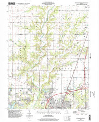 1998 Effingham North2002 Print · USGSEffingham and the surrounding prairie townships appear at the end of the millennium as a crossroads of rail and modern highway travel. Genealogists and local historians can trace the course of the Little Wabash River past Lake Pauline, the village of Sigel, and the northern edge of Effingham.
 - 1998 Map of Effingham South, 2002 Print
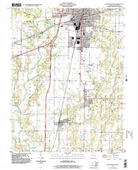 1998 Effingham South2002 Print · USGSSouthern Effingham County at the turn of the millennium shows a landscape defined by the intersection of major interstate travel and quiet township life. Researchers can trace the layout of Watson, Heartville, and Ewington or locate family plots at several rural Cemeteries.
End of results
Showing maps 1-2 of 2
Top cities near Effingham
- Altamont historical maps
- Neoga historical maps
- Teutopolis historical maps
- Dieterich historical maps
- Watson historical maps
- Stewardson historical maps
See more
Frequently asked questions
- What are the different types of historical maps available for Effingham?
- What is the oldest map of Effingham?
- Where can I purchase historical maps of Effingham for my home or office?
- Where can I download high-res historical maps of Effingham?
- Are there historical topographic maps available for Effingham?
- Is there historical aerial imagery available for Effingham?
- Where are historical maps of Effingham sourced from?