1990s Maps of Fayette County, Illinois
Explore 9 historic maps of Fayette County from the 1990s. These maps offer a rare glimpse into what life looked like during the 1990s — showing old roads, neighborhoods, homes, and landmarks that have changed or disappeared over time.
Whether you're researching your family's past, planning a metal detecting trip, or studying how Fayette County's landscape evolved across the 1990s, these high-resolution maps are a powerful tool for exploring the history of this region.
- Focus on a specific era: All maps on this page are from the 1990s, giving you a focused view of this time period.
- See what’s changed: Compare century-old streets, trails, and buildings to today's modern landscape using overlays and satellite layers.
- Research with precision: Use these maps for genealogy, historical research, land use analysis, or educational projects.
- View, download, or print: Maps are fully viewable online in high resolution, and can be downloaded or printed for your own records.
Start exploring Fayette County's history through authentic maps from the 1990s. This is your window into the past.
Fayette County, IL maps
(9)- 1998 Map of Ramsey Lake, 2002 Print
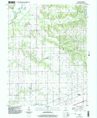
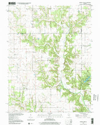 1998 Ramsey Lake2002 Print · USGSFayette County at the close of the century retains a landscape of quiet rural townships and family-named landmarks. Researchers can locate numerous ancestral sites including Donaldson Cem, Halford Chapel, and Little Hickory Ch near the banks of Ramsey Creek.
 - 1998 Map of Bingham, 2002 Print
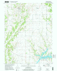 1998 Bingham2002 Print · USGSFayette County's rural townships are captured in the late nineties, featuring the village of Bingham and the recreational waters of Vandalia Lake. Genealogists can locate numerous family-named landmarks including Browning Cem, Pope Cem, and the Canaan Ch.
 - 1998 Map of Bald Knob, 2002 Print
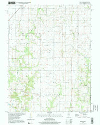 1998 Bald Knob2002 Print · USGSThe agricultural heart of Montgomery and Fayette counties is captured in the late twentieth century, showing the small-town life around Witt. Genealogists can trace family roots through sites like Armentrout Cemetery, Woodside Church, and the distinctive Bald Knob summit.
 - 1998 Map of Vera, 2002 Print
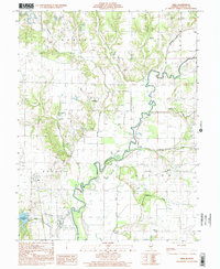 1998 Vera2002 Print · USGSFayette County is defined by the winding Kaskaskia River and its complex network of drainage ditches and tributaries in the late nineties. Genealogists and local historians can locate several rural burial sites and congregations, including Sharon Cem, Bolyard Cem, and Independence Ch.
 - 1998 Map of Fillmore, 2002 Print
 1998 Fillmore2002 Print · USGSMontgomery and Bond Counties appear here in the late 1990s, capturing a traditional landscape of prairie townships and creek-side settlements. Researchers can trace historic family names at Renshaw Cem, Neathery Cem, and the rural community at Van Burensburg.
 - 1998 Map of Ramsey, 2002 Print
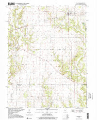
 1998 Ramsey2002 Print · USGSThe Fayette County countryside south of the Shelby County line is captured here in the late nineties, centered on the village of Ramsey. Family historians can trace numerous rural burial sites and landmarks like Twin Churches, Hayes Cem, and Mt Pleasant Ch.
 - 1998 Map of Altamont West, 2003 Print
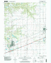 1998 Altamont West2003 Print · USGSFayette County at the end of the millennium shows a landscape defined by the oil industry and deep-rooted rural communities. Researchers can trace family history at St Pauls Cem, locate St Bonaventure Ch, or study the extent of the Loudon Field.
 - 1998 Map of Herrick, 2003 Print
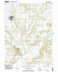 1998 Herrick2003 Print · USGSThe rural border of Shelby and Fayette counties comes into focus in the late nineties, centered on the village of Herrick. Genealogists can trace family heritage through numerous landmarks like Pleasant Grove Cem, Kaskaskia Ch, and the crossing at Lorton Bridge.
 - 1998 Map of Avena, 2003 Print
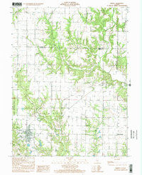
 1998 Avena2003 Print · USGSFayette County in the late 1990s showcases a landscape of rural townships and winding creek bottoms before the turn of the millennium. Researchers can trace family history through sites like Zion Cem, the settlement at Sefton, or the Miller Landing Strip.
End of results
Showing maps 1-9 of 9
Top cities of Fayette County
- Vandalia historical maps
- Avena historical maps
- St. Elmo historical maps
- Ramsey historical maps
- La Clede historical maps
- Brownstown historical maps
See more
Frequently asked questions
- What are the different types of historical maps available for Fayette County?
- What is the oldest map of Fayette County?
- Where can I purchase historical maps of Fayette County for my home or office?
- Where can I download high-res historical maps of Fayette County?
- Are there historical topographic maps available for Fayette County?
- Is there historical aerial imagery available for Fayette County?
- Where are historical maps of Fayette County sourced from?