1980s Maps of Fayette County, Illinois
Explore 16 historic maps of Fayette County from the 1980s. These maps offer a rare glimpse into what life looked like during the 1980s — showing old roads, neighborhoods, homes, and landmarks that have changed or disappeared over time.
Whether you're researching your family's past, planning a metal detecting trip, or studying how Fayette County's landscape evolved across the 1980s, these high-resolution maps are a powerful tool for exploring the history of this region.
- Focus on a specific era: All maps on this page are from the 1980s, giving you a focused view of this time period.
- See what’s changed: Compare century-old streets, trails, and buildings to today's modern landscape using overlays and satellite layers.
- Research with precision: Use these maps for genealogy, historical research, land use analysis, or educational projects.
- View, download, or print: Maps are fully viewable online in high resolution, and can be downloaded or printed for your own records.
Start exploring Fayette County's history through authentic maps from the 1980s. This is your window into the past.
Fayette County, IL maps
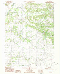
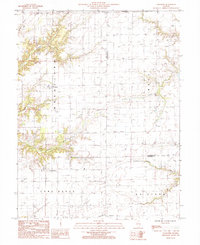
(16)- 1982 Map of Ramsey
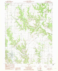 1982 Ramsey1982 Print · USGSFayette County in the early eighties shows a landscape of rail-served villages and deep-cut creek beds. Researchers can trace historic family burial sites like St Joseph Cem and Clark Cem or locate the distinctive Twin Churches.
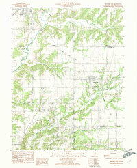
 - 1982 Map of Litchfield
 1982 Litchfield1982 Print · USGSThe coal and rail corridors of Central Illinois are captured here in the early eighties as the region balanced industrial mining with its agricultural roots. Researchers can trace family history through sites like Zelmer Memorial Cemetery or the grounds of Blackburn College and the Crown Mine No 1.
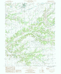
 - 1982 Map of Vera
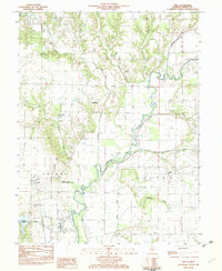 1982 Vera1982 Print · USGSFayette County's river valley and rural townships are captured here in the early eighties as the Kaskaskia River winds through Sefton and Sharon. Researchers can trace old family burial grounds like Bolyard Cem or locate the historic Vera and Linn settlements.
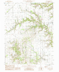
 - 1982 Map of Altamont West
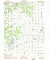 1982 Altamont West1982 Print · USGSFayette County at the start of the 1980s shows a landscape where industrial rail lines and rural tradition meet. Genealogists can locate several remote burial sites and schools, including Maplewood Cem, Rhodes Cem, and the Bethlehem Sch.
 - 1982 Map of Herrick
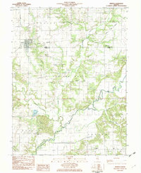 1982 Herrick1982 Print · USGSThe village of Herrick and the surrounding townships of Shelby and Fayette counties are captured here in the early 1980s. Researchers can locate numerous family-named landmarks, including Blankenship Cem, the Kaskaskia Ch, and the local Oil Field.
 - 1982 Map of Avena, 1983 Print
 1982 Avena1983 Print · USGSFayette County in the early eighties shows a landscape shaped by rail transport and river drainage. Researchers can locate family landmarks like Liberty Cem, the small settlement of Pruett, and churches such as Post Oak Ch or Fairview Ch.
 - 1983 Map of Beecher City
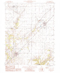
 1983 Beecher City1983 Print · USGSBeecher City and the surrounding prairie were hubs of rail and resource extraction in the early 1980s. Genealogists can locate family burial sites like Tipsword Cem and Hubbard Cem, or trace the tracks of the Baltimore and Ohio through Moccasin.
 - 1985 Map of Brownstown
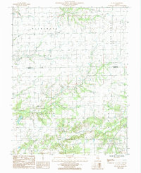
 1985 Brownstown1985 Print · USGSFayette County in the mid-1980s shows a landscape of steady agricultural life and active petroleum extraction. Researchers can trace rural property lines and landmarks near Brownstown, the settlement of Confidence, and the recreational waters of Gatch Lake.
 - 1985 Map of Carlyle Lake
 1985 Carlyle Lake1985 Print · USGSSouthwestern Illinois in the mid-eighties shows a landscape of growing commuter suburbs and massive water management projects. Genealogists and historians can locate family plots at Lakeview Memorial Gardens Cem or trace the early footprint of Southern Illinois Univ (Edwardsville).2 unique versions available
 - 1985 Map of Oskaloosa
 1985 Oskaloosa1985 Print · USGSClay County and the surrounding countryside appear in detail during the mid-1980s, showcasing the rural road networks and township divisions. Local researchers can trace family lands near Iola and the winding banks of Skillet Fork or Dismal Creek.
 - 1985 Map of Loogootee
 1985 Loogootee1985 Print · USGSLoogootee and St James are centered in this mid-1980s survey of the Fayette and Effingham county line during a period of steady agricultural and energy growth. Researchers can trace rural landmarks and watercourses like Little Hickory Creek, Dismal Creek, and a local Radio Tower.
 - 1985 Map of Kinmundy
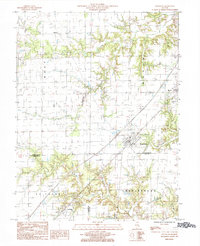
 1985 Kinmundy1985 Print · USGSIn the mid-eighties, the border of Fayette and Marion Counties centered on the rail hub of Kinmundy and the surrounding prairie. You can trace the Illinois Central Gulf line through Farina or locate old burial sites near Lone Grove Branch.
 - 1985 Map of St. Paul
 1985 St. Paul1985 Print · USGSMarion and Fayette counties are shown here in the mid-1980s, revealing a landscape shaped by the East Fork Kaskaskia River and its many branches. Researchers can locate the small community of St Paul, identify local cemeteries, and trace the elevation changes at Lowe Mound.
 - 1985 Map of Edgewood
 1985 Edgewood1985 Print · USGSThe prairie of Effingham and Clay counties is captured here in the mid-eighties, centered on the rail-oriented town of Edgewood. Genealogists and local historians can trace the rail corridor through Mason and La Clede or find family land near Fulfer Creek.
 - 1986 Map of Olney
 1986 Olney1986 Print · USGSSouth-central Illinois in the mid-eighties shows a landscape of small agricultural towns linked by historic rail lines and prairie preserves. Trace family roots and vanished rail stops near Kinmundy, the Prairie Chicken Sanctuary, and Salem.2 unique versions available
 - 1986 Map of Effingham
 1986 Effingham1986 Print · USGSCentral Illinois during the mid-eighties was a hub of rail travel and water recreation centered on the new reservoirs. Genealogists and historians can trace the rural landscape between Mattoon and Effingham, locating landmarks like St Paul Ch and Eagle Creek State Park.2 unique versions available
End of results
Showing maps 1-16 of 16
Top cities of Fayette County
- Vandalia historical maps
- Avena historical maps
- St. Elmo historical maps
- Ramsey historical maps
- La Clede historical maps
- Brownstown historical maps
See more
Frequently asked questions
- What are the different types of historical maps available for Fayette County?
- What is the oldest map of Fayette County?
- Where can I purchase historical maps of Fayette County for my home or office?
- Where can I download high-res historical maps of Fayette County?
- Are there historical topographic maps available for Fayette County?
- Is there historical aerial imagery available for Fayette County?
- Where are historical maps of Fayette County sourced from?