1920s Maps of Ford County, Illinois
Explore 3 historic maps of Ford County from the 1920s. These maps offer a rare glimpse into what life looked like during the 1920s — showing old roads, neighborhoods, homes, and landmarks that have changed or disappeared over time.
Whether you're researching your family's past, planning a metal detecting trip, or studying how Ford County's landscape evolved across the 1920s, these high-resolution maps are a powerful tool for exploring the history of this region.
- Focus on a specific era: All maps on this page are from the 1920s, giving you a focused view of this time period.
- See what’s changed: Compare century-old streets, trails, and buildings to today's modern landscape using overlays and satellite layers.
- Research with precision: Use these maps for genealogy, historical research, land use analysis, or educational projects.
- View, download, or print: Maps are fully viewable online in high resolution, and can be downloaded or printed for your own records.
Start exploring Ford County's history through authentic maps from the 1920s. This is your window into the past.
Ford County, IL maps
(3)- 1924 Map of Paxton, 1953 Print
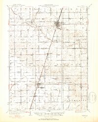 1924 Paxton1953 Print · USGSEast-central Illinois comes into focus during the mid-twenties as the rail lines and early airfields transformed the prairie. Researchers can locate dozens of family-named schools like Lily Dell School and trace the original layout of Chanute Flying Field.
 - 1927 Map of Paxton
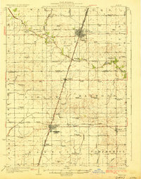 1927 Paxton1927 Print · USGSIllinois prairie life in the mid-twenties is captured here through a dense network of township schools and the rise of military aviation. Genealogists and local historians can trace family locations near Chanute Flying Field or find long-standing rural landmarks like Lily Dell School and Glen Cemetery.2 unique versions available
 - 1928 Map of Gibson City
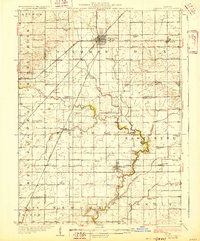 1928 Gibson City1928 Print · USGSCentral Illinois farming life is captured here in the late 1920s, dominated by the major rail junction at Gibson City. Genealogists can locate dozens of country schools like Scotland School and Caledonia School along the Sangamon River.2 unique versions available
End of results
Showing maps 1-3 of 3
Top cities of Ford County
- Paxton historical maps
- Gibson City historical maps
- Piper City historical maps
- Melvin historical maps
- Roberts historical maps
- Elliott historical maps
See more
Frequently asked questions
- What are the different types of historical maps available for Ford County?
- What is the oldest map of Ford County?
- Where can I purchase historical maps of Ford County for my home or office?
- Where can I download high-res historical maps of Ford County?
- Are there historical topographic maps available for Ford County?
- Is there historical aerial imagery available for Ford County?
- Where are historical maps of Ford County sourced from?