1970s Maps of Checkrow, Illinois
Explore 1 historic maps of Checkrow from the 1970s. These maps offer a rare glimpse into what life looked like during the 1970s — showing old roads, neighborhoods, homes, and landmarks that have changed or disappeared over time.
Whether you're researching your family's past, planning a metal detecting trip, or studying how Checkrow's landscape evolved across the 1970s, these high-resolution maps are a powerful tool for exploring the history of this region.
- Focus on a specific era: All maps on this page are from the 1970s, giving you a focused view of this time period.
- See what’s changed: Compare century-old streets, trails, and buildings to today's modern landscape using overlays and satellite layers.
- Research with precision: Use these maps for genealogy, historical research, land use analysis, or educational projects.
- View, download, or print: Maps are fully viewable online in high resolution, and can be downloaded or printed for your own records.
Start exploring Checkrow's history through authentic maps from the 1970s. This is your window into the past.
Checkrow, IL maps
(1)- 1974 Map of Bushnell East, 1978 Print
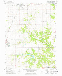 1974 Bushnell East1978 Print · USGSPrairie City and Bushnell sit at a vital rail crossroads during the mid-seventies, where agriculture meets early recreational development. Trace local lineage and industry through Mound Cem, the First Baptist Ch, and a large Strip Mine.
End of results
Showing maps 1-1 of 1
Top cities near Checkrow
- Bushnell historical maps
- Lewistown historical maps
- Cuba historical maps
- Avon historical maps
- Greenbush historical maps
- Industry historical maps
See more
Frequently asked questions
- What are the different types of historical maps available for Checkrow?
- What is the oldest map of Checkrow?
- Where can I purchase historical maps of Checkrow for my home or office?
- Where can I download high-res historical maps of Checkrow?
- Are there historical topographic maps available for Checkrow?
- Is there historical aerial imagery available for Checkrow?
- Where are historical maps of Checkrow sourced from?