1900s (20th Century) Maps of Table Grove, Illinois
Explore 11 historic maps of Table Grove from the 1900s (20th Century). These maps offer a rare glimpse into what life looked like during the 1900s — showing old roads, neighborhoods, homes, and landmarks that have changed or disappeared over time.
Whether you're researching your family's past, planning a metal detecting trip, or studying how Table Grove's landscape evolved across the 1900s, these high-resolution maps are a powerful tool for exploring the history of this region.
- Focus on a specific era: All maps on this page are from the 1900s, giving you a focused view of this time period.
- See what’s changed: Compare century-old streets, trails, and buildings to today's modern landscape using overlays and satellite layers.
- Research with precision: Use these maps for genealogy, historical research, land use analysis, or educational projects.
- View, download, or print: Maps are fully viewable online in high resolution, and can be downloaded or printed for your own records.
Start exploring Table Grove's history through authentic maps from the 1900s. This is your window into the past.
Table Grove, IL maps
(11)- 1918 Map of Vermont
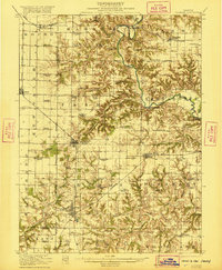
 1918 Vermont1918 Print · USGSThe rural prairie of McDonough and Fulton counties is captured here just after the Great War, during the height of the railroad era. Genealogists can locate specific homestead sites near New Philadelphia or trace the many rural schoolhouses like Mud Acre School and Harvey School.2 unique versions available
 - 1921 Map of Vermont
 1921 Vermont1921 Print · USGSWestern Illinois prairie and river breaks are documented here just after the Great War, showing a landscape defined by small family farms. Researchers can trace rural school districts and pioneer churches like Mud Acre School, Mt Pleasant Church, and the settlement at Bernadotte.2 unique versions available
 - 1947 Map of Vermont, 1979 Print
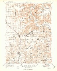
 1947 Vermont1979 Print · USGSIn the mid-century period, the area around Vermont and Table Grove was shaped by military activity and mining. Local historians can locate the Camp Ellis Military Reservation and historic schoolhouses like Harvey Sch and Cox Sch.
 - 1948 Map of Vermont
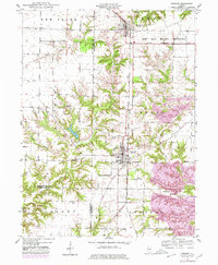
 1948 Vermont1948 Print · USGSWestern Illinois was transitioning into the post-war era when this survey recorded the massive Camp Ellis Military Reservation alongside established farming townships. Genealogists can locate family-named landmarks like Easley Cem and Mud Acre Sch.2 unique versions available
 - 1949 Map of Vermont
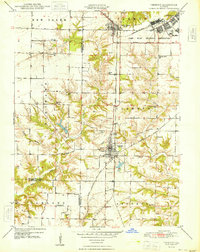
 1949 Vermont1949 Print · USGSFulton County and the surrounding tri-county area appear here shortly after the war, centered on the massive Camp Ellis Military Reservation. Researchers can trace the vanished barracks and rail spurs of the camp alongside rural landmarks like the Little Brick School and Bernadotte Bridge.2 unique versions available
 - 1958 Map of Burlington, 1968 Print
 1958 Burlington1968 Print · USGSThe tri-state river country of Iowa, Illinois, and Missouri is captured here in the mid-fifties, dominated by the Mississippi River and major rail lines. Genealogists and historians can trace the development of river towns like Keokuk or locate the sprawling Iowa Army Ammunition Plant.4 unique versions available
 - 1961 Map of Burlington
 1961 Burlington1961 Print · USGSThe tri-state borderlands along the Mississippi River are captured here during the late fifties and early sixties, showing the vital river-and-rail economy of Iowa, Illinois, and Missouri. Genealogists and historians can trace the development of major hubs like Galesburg and Macomb alongside landmark sites such as the Iowa Ordnance Plant and the historic river town of Nauvoo.
 - 1963 Map of Burlington
 1963 Burlington1963 Print · USGSThe tri-state river country of the Mississippi and Illinois valleys comes alive in this mid-century survey. Genealogists and historians can trace the industrial and academic growth of the region, from the Iowa Ordnance Plant to campuses like Knox College and Western Illinois University.
 - 1985 Map of Macomb
 1985 Macomb1985 Print · USGSWest Central Illinois in the mid-eighties shows a robust network of river towns and rail corridors spanning from the Illinois River to the Lamoine. Genealogists and historians can trace the foundations of Macomb, find rural landmarks like Pennington Point, or locate early conservation sites like Argyle Lake State Park.
 - 1989 Map of Macomb
 1989 Macomb1989 Print · USGSWest Central Illinois in the late eighties shows a landscape of river-bottom conservation and rail-town commerce. Researchers can trace the extensive wetlands of the Illinois River or locate historic transport hubs in Macomb, Colchester, and Beardstown.
 - 1990 Map of Burlington
 1990 Burlington1990 Print · USGSThe tri-state confluence of Iowa, Illinois, and Missouri is mapped here at the end of the twentieth century. Genealogists and historians can trace the riverfront heritage of Burlington, Keokuk, and Fort Madison, or locate sites like the Battle of Athens State Historic Site.2 unique versions available
End of results
Showing maps 1-11 of 11
Top cities near Table Grove
- Macomb historical maps
- Bushnell historical maps
- Cuba historical maps
- Astoria historical maps
- Vermont historical maps
- Industry historical maps
See more
Frequently asked questions
- What are the different types of historical maps available for Table Grove?
- What is the oldest map of Table Grove?
- Where can I purchase historical maps of Table Grove for my home or office?
- Where can I download high-res historical maps of Table Grove?
- Are there historical topographic maps available for Table Grove?
- Is there historical aerial imagery available for Table Grove?
- Where are historical maps of Table Grove sourced from?