1960s Maps of Gallatin County, Illinois
Explore 7 historic maps of Gallatin County from the 1960s. These maps offer a rare glimpse into what life looked like during the 1960s — showing old roads, neighborhoods, homes, and landmarks that have changed or disappeared over time.
Whether you're researching your family's past, planning a metal detecting trip, or studying how Gallatin County's landscape evolved across the 1960s, these high-resolution maps are a powerful tool for exploring the history of this region.
- Focus on a specific era: All maps on this page are from the 1960s, giving you a focused view of this time period.
- See what’s changed: Compare century-old streets, trails, and buildings to today's modern landscape using overlays and satellite layers.
- Research with precision: Use these maps for genealogy, historical research, land use analysis, or educational projects.
- View, download, or print: Maps are fully viewable online in high resolution, and can be downloaded or printed for your own records.
Start exploring Gallatin County's history through authentic maps from the 1960s. This is your window into the past.
Gallatin County, IL maps
(7)- 1961 Map of Paducah
 1961 Paducah1961 Print · USGSThe Lower Ohio Valley at mid-century is a landscape defined by its great rivers and newly formed reservoirs. Researchers can trace the riverfronts of Paducah and Metropolis, or locate smaller settlements like Old Shawneetown and Cave in Rock along the banks.2 unique versions available
 - 1963 Map of Ridgway, 1964 Print
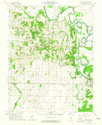
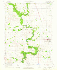 1963 Ridgway1964 Print · USGSGallatin County’s river-fed plains are captured here in the early sixties, showing a landscape defined by agriculture and extraction. Genealogists and historians can trace family locations near Ridgway, find rural landmarks like Zion Ch, or study the Omaha Oil and Gas Field.2 unique versions available
 - 1963 Map of Norris City, 1964 Print
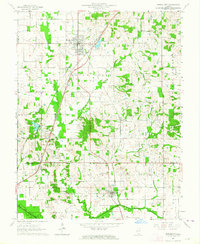 1963 Norris City1964 Print · USGSSouthern Illinois during the early sixties is captured here at the rail junction of Norris City and the rural prairies of White County. Researchers can trace ancestral sites like the Odd Fellows Cem and vanished landmarks such as Gossett Station.2 unique versions available
 - 1963 Map of Eldorado, 1966 Print
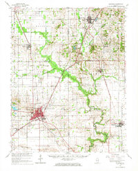 1963 Eldorado1966 Print · USGSSouthern Illinois in the early sixties shows a landscape shaped by coal, oil, and the crossing of three major railroads. Genealogists can trace family names at Gholson Cem and Lantham Cem or locate the old Broughton Sch and Gossett Station.
 - 1964 Map of New Haven SW
 1964 New Haven SW1964 Print · USGSGallatin County's transition from river bottomlands to upland ridges is captured here in the mid-1960s. Family researchers can locate numerous rural landmarks such as Old Cottonwood Cem, St Patricks Ch, and the high ground of Gold Hill.
 - 1964 Map of Paducah
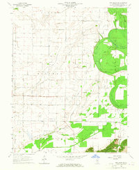
 1964 Paducah1964 Print · USGSThe river-and-rail corridor of Southern Illinois and Western Kentucky is captured here during the height of the mid-century industrial era. Genealogists and researchers can trace local landmarks across several counties, from the rail yards of Paducah to the waters of Crab Orchard Lake and Kentucky Reservoir.2 unique versions available
 - 1964 Map of New Haven, 1965 Print
 1964 New Haven1965 Print · USGSSouthern Illinois at the height of the 1960s oil boom reveals a landscape shaped by the Little Wabash River and deep-rooted farm life. Genealogists can trace family heritage through numerous rural landmarks like Union Ridge Ch Cem, Herald, and Plainview Ch.2 unique versions available
End of results
Showing maps 1-7 of 7
Top cities of Gallatin County
- Shawneetown historical maps
- Ridgway historical maps
- Equality historical maps
- New Haven historical maps
- Omaha historical maps
- Junction historical maps
See more
Frequently asked questions
- What are the different types of historical maps available for Gallatin County?
- What is the oldest map of Gallatin County?
- Where can I purchase historical maps of Gallatin County for my home or office?
- Where can I download high-res historical maps of Gallatin County?
- Are there historical topographic maps available for Gallatin County?
- Is there historical aerial imagery available for Gallatin County?
- Where are historical maps of Gallatin County sourced from?