1900s (20th Century) Maps of White Hall, Illinois
Explore 7 historic maps of White Hall from the 1900s (20th Century). These maps offer a rare glimpse into what life looked like during the 1900s — showing old roads, neighborhoods, homes, and landmarks that have changed or disappeared over time.
Whether you're researching your family's past, planning a metal detecting trip, or studying how White Hall's landscape evolved across the 1900s, these high-resolution maps are a powerful tool for exploring the history of this region.
- Focus on a specific era: All maps on this page are from the 1900s, giving you a focused view of this time period.
- See what’s changed: Compare century-old streets, trails, and buildings to today's modern landscape using overlays and satellite layers.
- Research with precision: Use these maps for genealogy, historical research, land use analysis, or educational projects.
- View, download, or print: Maps are fully viewable online in high resolution, and can be downloaded or printed for your own records.
Start exploring White Hall's history through authentic maps from the 1900s. This is your window into the past.
White Hall, IL maps
(7)- 1924 Map of Roodhouse, 1958 Print
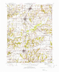 1924 Roodhouse1958 Print · USGSGreene County thrived as a railroad hub in the 1920s, defined by the busy yards at Roodhouse and the nearby center of White Hall. Genealogists can locate dozens of vanished rural landmarks, including the Swamp College School and the Martin Prairie Church.2 unique versions available
 - 1926 Map of Roodhouse
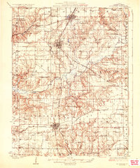 1926 Roodhouse1926 Print · USGSGreene County in the mid-1920s is a landscape of established rail towns and a high density of country schoolhouses. Genealogists and historians can trace family roots through numerous local landmarks like Swamp College School, Oakland Church, and the settlement of Berdan.2 unique versions available
 - 1948 Map of Quincy
 1948 Quincy1948 Print · USGSThe Mississippi and Illinois River valleys are captured at a post-war crossroads as rail and river travel met the expanding highway system. Genealogists can trace family settlements from Quincy to Hannibal and smaller towns like Vandalia and Jerseyville.2 unique versions available
 - 1956 Map of Quincy, 1967 Print
 1956 Quincy1967 Print · USGSThe river and rail corridors of the Illinois-Missouri border are documented here during the mid-1950s. Researchers can trace historic river landings and regional transit hubs from Quincy and Hannibal to smaller settlements like Meredosia and Roodhouse.3 unique versions available
 - 1983 Map of Roodhouse West, 1984 Print
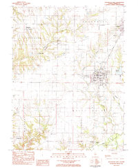 1983 Roodhouse West1984 Print · USGSGreene County agriculture and rail industry intersect in the early eighties between White Hall and Patterson. Researchers can locate numerous family-named burial grounds like Hanks Cem and Hicks Cem or trace the Illinois Central Gulf line.
 - 1983 Map of Roodhouse East, 1984 Print
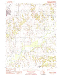 1983 Roodhouse East1984 Print · USGSGreene County in the early eighties shows the intersection of the Illinois Central Gulf railroad with a landscape of family farms and emerging industry. Genealogists can trace rural roots through numerous burial grounds like Tumison Cem and Martins Prairie Cem or locate the community landmarks of Roodhouse.
 - 1985 Map of Jerseyville
 1985 Jerseyville1985 Print · USGSThe confluence of the Illinois and Mississippi rivers defines this 1980s landscape of fertile bottomlands and rail-hub towns. Genealogists and historians can trace the foundations of communities like Jerseyville and White Hall alongside the Oak Grove Cem and St Mary Church.2 unique versions available
End of results
Showing maps 1-7 of 7
Top cities near White Hall
- Carrollton historical maps
- Winchester historical maps
- Roodhouse historical maps
- Greenfield historical maps
- Murrayville historical maps
- Patterson historical maps
See more
Frequently asked questions
- What are the different types of historical maps available for White Hall?
- What is the oldest map of White Hall?
- Where can I purchase historical maps of White Hall for my home or office?
- Where can I download high-res historical maps of White Hall?
- Are there historical topographic maps available for White Hall?
- Is there historical aerial imagery available for White Hall?
- Where are historical maps of White Hall sourced from?