1980s Maps of Goodwine, Illinois
Explore 2 historic maps of Goodwine from the 1980s. These maps offer a rare glimpse into what life looked like during the 1980s — showing old roads, neighborhoods, homes, and landmarks that have changed or disappeared over time.
Whether you're researching your family's past, planning a metal detecting trip, or studying how Goodwine's landscape evolved across the 1980s, these high-resolution maps are a powerful tool for exploring the history of this region.
- Focus on a specific era: All maps on this page are from the 1980s, giving you a focused view of this time period.
- See what’s changed: Compare century-old streets, trails, and buildings to today's modern landscape using overlays and satellite layers.
- Research with precision: Use these maps for genealogy, historical research, land use analysis, or educational projects.
- View, download, or print: Maps are fully viewable online in high resolution, and can be downloaded or printed for your own records.
Start exploring Goodwine's history through authentic maps from the 1980s. This is your window into the past.
Goodwine, IL maps
(2)- 1984 Map of Watseka, 1985 Print
 1984 Watseka1985 Print · USGSThe Illinois-Indiana borderlands thrived on a dense rail and river network during the mid-eighties. Genealogists and local historians can trace the foundations of rural life through landmarks like St Josephs College, the Iroquois Hospital, and towns like Milford and Beaverville.
 - 1986 Map of Claytonville
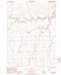 1986 Claytonville1986 Print · USGSIroquois County prairie life is documented in the 1980s across the townships of Ash Grove and Lovejoy. Genealogists and local historians can trace small-town footprints in Claytonville and Goodwine or locate family plots at several rural Cem sites.
End of results
Showing maps 1-2 of 2
Top cities near Goodwine
- Hoopeston historical maps
- Watseka historical maps
- Gilman historical maps
- Onarga historical maps
- Milford historical maps
- Rossville historical maps
See more
Frequently asked questions
- What are the different types of historical maps available for Goodwine?
- What is the oldest map of Goodwine?
- Where can I purchase historical maps of Goodwine for my home or office?
- Where can I download high-res historical maps of Goodwine?
- Are there historical topographic maps available for Goodwine?
- Is there historical aerial imagery available for Goodwine?
- Where are historical maps of Goodwine sourced from?